Approximate Location Map
Large Map »
Latitude: 50.7282 / 50°43'41"N
Longitude: -1.9424 / 1°56'32"W
OS Eastings: 404158
OS Northings: 92069
OS Grid: SZ041920
Mapcode National: GBR XYG.HW
Mapcode Global: FRA 67T5.32C
Plus Code: 9C2WP3H5+72
Entry Name: Water Tower
Listing Date: 13 September 1995
Grade: II
Source: Historic England
Source ID: 1224087
English Heritage Legacy ID: 412523
ID on this website: 101224087
Location: Upper Parkstone, Bournemouth, Christchurch and Poole, Dorset, BH14
County: Bournemouth, Christchurch and Poole
Parish: Non Civil Parish
Built-Up Area: Poole
Traditional County: Dorset
Lieutenancy Area (Ceremonial County): Dorset
Church of England Parish: Parkstone St Peter and St Osmund with Branksea St Mary
Church of England Diocese: Salisbury
Tagged with: Water tower
POOLE
SZ09SW MANSFIELD ROAD, Upper Parkstone
958-1/5/251 (West side)
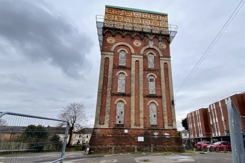
Water Tower
II
Water tower. Late C19. For Dorset Water Board. Red brick with
white brick dressings, some limestone and terracotta
dressings, with cast-iron tank and other ironwork. Square
plan.
3-stage tower with 2-bay sides, carrying a cast-iron tank.
Tower has battered plinth of red brick in English bond with 2
recessed bands of paler red brick and limestone roll moulding
to top of plinth; broken by round-headed doorway to rear
(regarding street elevation as front).
Sides are divided into 2 bays by giant white brick pilaster
strips to angles and centre of each side. Pilaster strips have
tall, thin sunk panels of red brick with round-arched heads,
and bands of red brick above, defining "capitals". Round
arches of white brick join pilaster strips and frame 3 tiers
of tall iron-framed windows with round-arched heads of white
brick, except to rear which is windowless; dentilled brick
string courses at stage levels within giant arches. Large
terracotta paterae to spandrels of arches joining pilaster
strips and round-arched corbel frieze.
Cast-iron brackets between arches of corbel frieze support
iron railing and timber deck of walkway round base of tank,
directly below corbel frieze. Tank has pattern of 7 square
panels in 3 tiers, framing circle joined to courses by
diagonals. Central circle to street side frames medallion
lettered round rim JOHN ABBOT & CO GREENHEAD-ON-TYNE and in
centre LIMITED 1884. INTERIOR not inspected.
Listing NGR: SZ0415892069
External links are from the relevant listing authority and, where applicable, Wikidata. Wikidata IDs may be related buildings as well as this specific building. If you want to add or update a link, you will need to do so by editing the Wikidata entry.


Other nearby listed buildings
