Approximate Location Map
Large Map »
Latitude: 51.4863 / 51°29'10"N
Longitude: -0.1736 / 0°10'25"W
OS Eastings: 526907
OS Northings: 177954
OS Grid: TQ269779
Mapcode National: GBR 5P.6C
Mapcode Global: VHGQY.YW2Z
Plus Code: 9C3XFRPG+GH
Entry Name: Mallord House
Listing Date: 9 March 1982
Grade: II
Source: Historic England
Source ID: 1225537
English Heritage Legacy ID: 421951
ID on this website: 101225537
Location: Chelsea, Kensington and Chelsea, London, SW3
County: London
District: Kensington and Chelsea
Electoral Ward/Division: Stanley
Parish: Non Civil Parish
Built-Up Area: Kensington and Chelsea
Traditional County: Middlesex
Lieutenancy Area (Ceremonial County): Greater London
Church of England Parish: Chelsea St John with St Andrew
Church of England Diocese: London
Tagged with: House
TQ 2677 NE
61/20
9.3.82
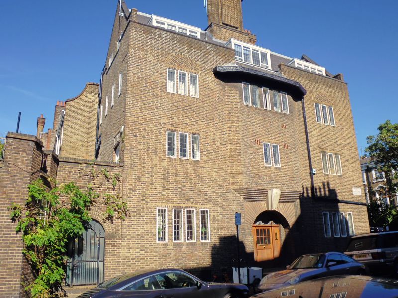
MALLORD STREET SW3
Nos 2 and 4 (Mallord House)
II
Town house. 1911. Ralph Knott. Brown brick. Slated roof. Three storeys, dormers
and basement. Three windows wide. Symmetrical facade to Mallord Street. Central
arched entrance with radiating tile and brick voussoirs and stone keystone with
"Mallord House". Original door and leaded fanlight over. Central corbelled 2 storey
oriel above with casement windows. To sides casement windows with flush brick
mullions. Second floor relieving arches over. Parapet and pitched roof, except over
centre where roof drops to eaves over oriel, with lead gutter showing hunting scene in
relief. Large central chimney stack. Three dormers. One storey wing to left with
service entrance and garage. Two window return with gable to right, on Old Church
Street. Area surrounds.
Listing NGR: TQ2690777954
External links are from the relevant listing authority and, where applicable, Wikidata. Wikidata IDs may be related buildings as well as this specific building. If you want to add or update a link, you will need to do so by editing the Wikidata entry.


Other nearby listed buildings
