Approximate Location Map
Large Map »
Latitude: 51.5058 / 51°30'20"N
Longitude: -0.1358 / 0°8'8"W
OS Eastings: 529478
OS Northings: 180187
OS Grid: TQ294801
Mapcode National: GBR FG.PD
Mapcode Global: VHGQZ.LFK0
Plus Code: 9C3XGV47+8M
Entry Name: Schomberg House
Listing Date: 5 February 1970
Grade: II*
Source: Historic England
Source ID: 1225814
English Heritage Legacy ID: 422689
ID on this website: 101225814
Location: St James's, Westminster, London, SW1Y
County: London
District: City of Westminster
Electoral Ward/Division: St James's
Parish: Non Civil Parish
Built-Up Area: City of Westminster
Traditional County: Middlesex
Lieutenancy Area (Ceremonial County): Greater London
Church of England Parish: St James Piccadilly
Church of England Diocese: London
Tagged with: House
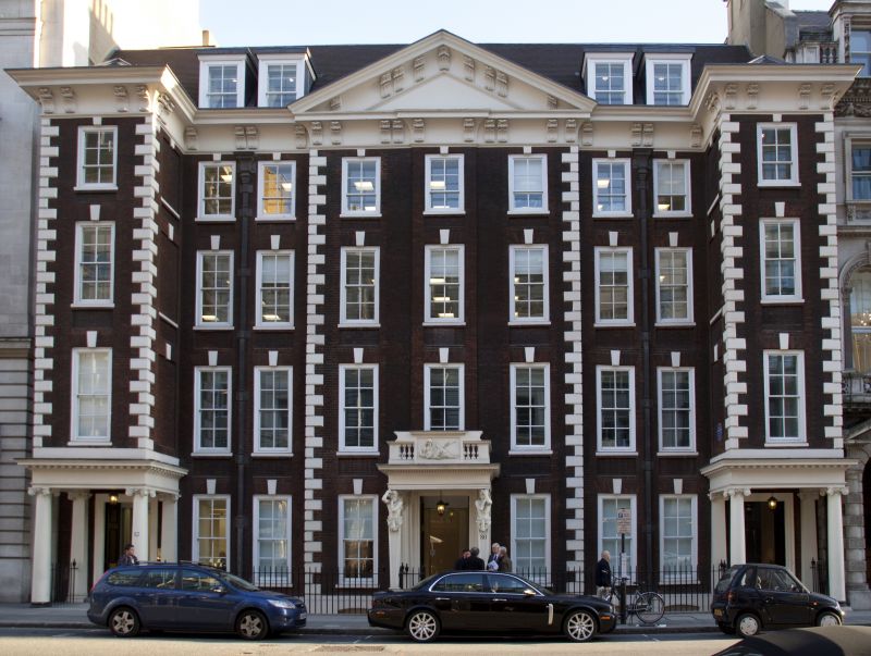
TQ 2980 SW CITY OF WESTMINSTER PALL MALL SW1
81/57 (South side)
5.2.70 Nos 80 to 82 consec.
(Schomberg House)
GV II*
Town mansion. 1698 for the Duke of Schomberg. Later alterations
and additions. Brown brick with red brick dressings and stone
quoining, slate roof. 4 storeys and basement. 9 bays wide with 3 bay
pedimented centre slightly advanced and projecting single bay flanking
wings, the eastern left half of elevation rebuilt restoring the original
symmetry of the design in the 1960s. Central projecting caryatid
porch of painted Coade stone (dated 1791) but no doorway behind it,
the entrance at foot of west wing with Ionic columns and bracketed
cornice. Long, narrow, renewed glazing bar sash windows flush framed
with flat gauged red brick arches, keystones and red brick dressings.
The centre bay has vertical "lacing". Coved eaves cornice together
with pediment have carved modillion brackets. Coade stone tablet
on 1st floor featuring an allegory of Painting. Plaque on west
wing commemorating residence of Thomas Gainsborough, the painter.
Rare survival of Cl7 town mansion.
Survey of London; vol XXIX
Listing NGR: TQ2948480180
External links are from the relevant listing authority and, where applicable, Wikidata. Wikidata IDs may be related buildings as well as this specific building. If you want to add or update a link, you will need to do so by editing the Wikidata entry.


Other nearby listed buildings
