Approximate Location Map
Large Map »
Latitude: 51.5434 / 51°32'36"N
Longitude: -0.0421 / 0°2'31"W
OS Eastings: 535867
OS Northings: 184541
OS Grid: TQ358845
Mapcode National: GBR K2.D2J
Mapcode Global: VHGQV.7G3N
Plus Code: 9C3XGXV5+95
Entry Name: Forecourt Wall and Railings to South Hackney Upper School
Listing Date: 4 February 1975
Grade: II
Source: Historic England
Source ID: 1226404
English Heritage Legacy ID: 423660
ID on this website: 101226404
Location: Homerton, Hackney, London, E9
County: London
District: Hackney
Electoral Ward/Division: Hackney Wick
Parish: Non Civil Parish
Built-Up Area: Hackney
Traditional County: Middlesex
Lieutenancy Area (Ceremonial County): Greater London
Church of England Parish: St Luke Homerton Terrace
Church of England Diocese: London
Tagged with: Wall
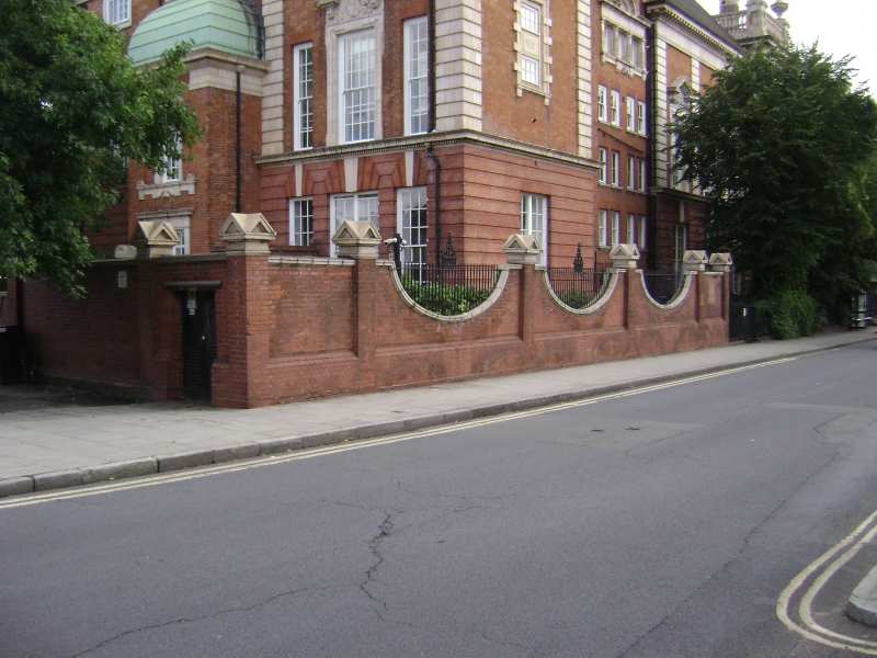
1. CASSLAND ROAD E9
5013
(North Side)
----------------
Forecourt Wall and Railings
to South Hackney Upper School
TQ 55R4 26/98
II
2.
Circa 190O red brick wall with high plinth. Square piers, with pedimented stone
tops, at intervals. Between the piers the walls are lowered in deep scallops with
stone coping and the spaces filled with wrought iron railings. Before centre-piece
of building simple wrought iron railings on stone plinth, Walls continue along
east and west boundaries.
Listing NGR: TQ3586784541
External links are from the relevant listing authority and, where applicable, Wikidata. Wikidata IDs may be related buildings as well as this specific building. If you want to add or update a link, you will need to do so by editing the Wikidata entry.


Other nearby listed buildings
