Approximate Location Map
Large Map »
Latitude: 51.5424 / 51°32'32"N
Longitude: -0.0455 / 0°2'43"W
OS Eastings: 535632
OS Northings: 184424
OS Grid: TQ356844
Mapcode National: GBR J7.K65
Mapcode Global: VHGQV.5H8F
Plus Code: 9C3XGXR3+XQ
Entry Name: 20-54, Cassland Road E9
Listing Date: 24 April 1951
Grade: II
Source: Historic England
Source ID: 1226405
English Heritage Legacy ID: 423661
ID on this website: 101226405
Location: South Hackney, Hackney, London, E9
County: London
District: Hackney
Electoral Ward/Division: Hackney Wick
Parish: Non Civil Parish
Built-Up Area: Hackney
Traditional County: Middlesex
Lieutenancy Area (Ceremonial County): Greater London
Church of England Parish: St John of Jerusalem South Hackney
Church of England Diocese: London
Tagged with: Building
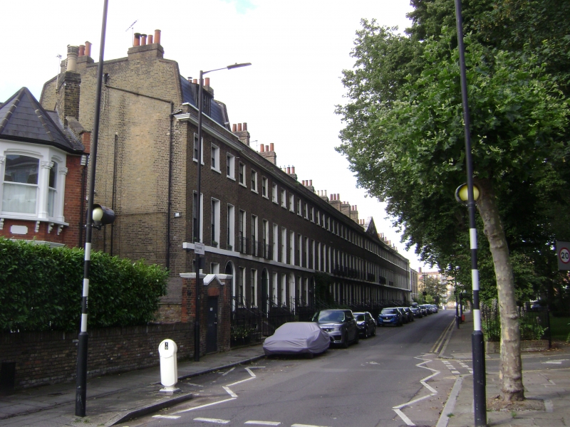
1. CASSLAND ROAD E9
5013
(South Side)
----------------
Nos 20 to 54 (even)
TQ 3584 26/89 24.4.51.
II GV
2.
Symmetrical early C19 terrace, each house 3 storeys and basement, 3 windows. Central
pedimented feature covering 2 houses has garlands and coat of arms in pediment.
Stock brick. Stone cornice and stone parapet coping. (East end house has raised
slated mansard with dormer). 1st floor cill band. Gauged flat brick arches to
sash windows with glazing bars, those on 1st floor long and with ornamental cast
iron balconies. 5 steps to doors of 6 flat panels, with cornice head and radial
fanlight, in round-arched stuccoed recess. Cast iron handrails to steps. Group
value.
Nos 20 to 54 (even) form a group.
Listing NGR: TQ3563284424
External links are from the relevant listing authority and, where applicable, Wikidata. Wikidata IDs may be related buildings as well as this specific building. If you want to add or update a link, you will need to do so by editing the Wikidata entry.


Other nearby listed buildings
