Approximate Location Map
Large Map »
Latitude: 52.0646 / 52°3'52"N
Longitude: -2.2172 / 2°13'2"W
OS Eastings: 385204
OS Northings: 240713
OS Grid: SO852407
Mapcode National: GBR 1HP.J8G
Mapcode Global: VH93D.JC6M
Plus Code: 9C4V3Q7M+R4
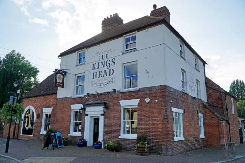
Entry Name: The Kings Head Public House
Listing Date: 13 May 1982
Grade: II
Source: Historic England
Source ID: 1227322
English Heritage Legacy ID: 425044
ID on this website: 101227322
Location: Upton upon Severn, Malvern Hills, Worcestershire, WR8
County: Worcestershire
District: Malvern Hills
Civil Parish: Upton-upon-Severn
Built-Up Area: Upton upon Severn
Traditional County: Worcestershire
Lieutenancy Area (Ceremonial County): Worcestershire
Church of England Parish: Upton-on-Severn
Church of England Diocese: Worcester
Tagged with: Pub
UPTON-UPON-SEVERN RIVERSIDE
SO 8540
2/4
13.5.82 The Kings Head Public
House
GV
II
Mid C18 brick inn on earlier core, altered in C19. L-plan with hipped plain tile
roofs and big brick stacks in angle. Three-storey. Two window range of C19 sliding
sashes and pilastered central doorcase, upper storeys now painted. Attached to S is
2-storey stable with hipped roof and arched carriage entrance, a C18 brick refacing of
C17 timber frame structure with queen-strut collar-and-tie beam roof. Brick range to
NW with plain tile roof, half-hipped at west gable.
Listing NGR: SO8520440713
External links are from the relevant listing authority and, where applicable, Wikidata. Wikidata IDs may be related buildings as well as this specific building. If you want to add or update a link, you will need to do so by editing the Wikidata entry.


Other nearby listed buildings
