Approximate Location Map
Large Map »
Latitude: 50.7327 / 50°43'57"N
Longitude: -2.7614 / 2°45'41"W
OS Eastings: 346361
OS Northings: 92838
OS Grid: SY463928
Mapcode National: GBR PP.0B67
Mapcode Global: FRA 5734.N1N
Plus Code: 9C2VP6MQ+3C
Entry Name: 46 and 48, St Michael's Lane
Listing Date: 19 September 1975
Grade: II
Source: Historic England
Source ID: 1227777
English Heritage Legacy ID: 402223
ID on this website: 101227777
Location: Bridport, Dorset, DT6
County: Dorset
Civil Parish: Bridport
Built-Up Area: Bridport
Traditional County: Dorset
Lieutenancy Area (Ceremonial County): Dorset
Church of England Parish: Bridport St Mary
Church of England Diocese: Salisbury
Tagged with: Building
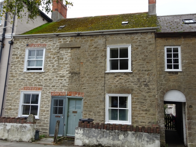
1.
5191 ST MICHAEL'S LANE
(West Side)
Nos 46 & 48
SY 4692 3/400
II GV
2.
Possibly C18. Rubble. Pitched tile roof. 2 storeys. 2 ranges of cased
sashes. 1 blocked window on lst floor. 2 modern doors.
Nos 36 to 48 (even) form a group.
Listing NGR: SY4635992835
External links are from the relevant listing authority and, where applicable, Wikidata. Wikidata IDs may be related buildings as well as this specific building. If you want to add or update a link, you will need to do so by editing the Wikidata entry.


Other nearby listed buildings
