Approximate Location Map
Large Map »
Latitude: 50.7328 / 50°43'57"N
Longitude: -2.762 / 2°45'43"W
OS Eastings: 346316
OS Northings: 92849
OS Grid: SY463928
Mapcode National: GBR PP.0B0Q
Mapcode Global: FRA 5734.MSN
Plus Code: 9C2VP6MQ+45
Entry Name: 40 St Michael's Lane and attached buildings to the rear and north-west
Listing Date: 19 September 1975
Last Amended: 26 June 2013
Grade: II
Source: Historic England
Source ID: 1287500
English Heritage Legacy ID: 402221
ID on this website: 101287500
Location: Bridport, Dorset, DT6
County: Dorset
Civil Parish: Bridport
Built-Up Area: Bridport
Traditional County: Dorset
Lieutenancy Area (Ceremonial County): Dorset
Church of England Parish: Bridport St Mary
Church of England Diocese: Salisbury
Tagged with: Building
Commercial premises, formerly a warehouse/workshop. Late C18. The attached buildings or former walks to the rear and north-west have late-C19 and early-C20 origins. There are late-C20 alterations.
MATERIALS: 40 St Michael's Lane is built of coursed, hammer-dressed stone rubble under a roof of corrugated metal sheeting; its rear addition is brick, as are the parallel ranges to the rear and north-west, though some incorporate random stone rubble. The roofs to the rear ranges are a mix of slate, glass panels, and corrugated sheeting.
PLAN: 40 St Michael's Lane is rectangular on plan, fronting onto the west side of the road. It is of three storeys with a narrow two-storey addition to the rear (west). Attached to the rear are two long, narrow ranges (formerly part of Ewens and Turner's works) that are orientated west-east with a former open walk between them. Parallel to and abutting the north range are a series of further ranges, formerly part of the late-C19 and early-C20 works of William Gale and Robert Hounsell. These ranges incorporate the remains of earlier walks, both open and covered, and most of them originally extended westwards towards the river but have been reduced in length. At their western end is a flat-roofed addition (Lilliput Building) of the mid-C20 which is not of special interest.
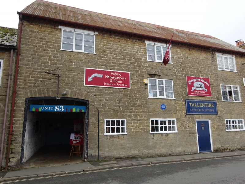
DESCRIPTION: the principal (east) elevation to 40 ST MICHAEL'S LANE is of five bays and three storeys with an attic. The ground floor has a tall segmental-headed carriageway opening to the far left with stone voussoirs to the arch. To the right is a symmetrical arrangement of openings: an entrance to bay two that has been partly blocked and replaced with a two-light casement; a three-light casement to bay three; bay four has an entrance; and bay five a three-light casement. The ground-floor windows are C19. The two upper floors each have an arrangement of late-C18 three-light casements to alternate bays; the first-floor window to the left-hand bay has been blocked and is partly overlaid by the carriageway. The window openings all have splayed lintels of dressed stone. To the rear is a narrow two-storey addition of the late C18/early C19. The ground-floor openings have been altered or blocked with a modern pair of doors inserted in a widened opening to the centre, while those to the first floor have multi-pane casements; all have gauged brick lintels. There is a lead rainwater hopper at the junction between this addition and the north range. Internally, the ground floor of No. 40 St Michael's Lane has a floor of stone flags and slim cast-iron columns support the upper floors. There are large axial beams; those to the first and second floors are chamfered with simple run out stops. On the second floor slender steel uprights have been added to carry the floors above, and there is also a large timber trap door which opens onto the carriageway below. In the attic the roof timbers are exposed and include A-frame principal rafters with two rows of staggered butt purlins to each side. The carriageway provides access to the rear of No.40 and has a doorway in its north wall which leads to the upper floors of No.40, above which is a loading door.
The SOUTH RANGE has north-light roofs and is mostly single storey except at its west end where a former open space beneath a first-floor building which is carried on steel girders has been infilled with a wall of concrete blocks and a window on its north side. A 1929 plan shows that parts of the range were used as a carpenter's shop, for balling and spooling and for twine drying; the western end which was a tarring shed and for storing coal was partially rebuilt in 1935/6. Within the buildings, the roofs are carried on asymmetrical trusses which rest on pillars of brick and concrete blocks along the north side of the building. Attached to the west end of this south range is a late-C19 two-storey building described as a store on a plan of 1929. Its south elevation is built mostly of stone rubble and contains a number of blocked window and door openings; two late-C20 windows have been inserted at first floor. To each gable end is a large arched opening; the one in the west end is partly obscured by a later lean-to, while the opening in the east gable wall has been blocked. Until the late C20 the north elevation had closely-spaced cast-iron windows at first floor, possibly for a workshop, but these have been replaced with uPVC windows, as have those to the ground floor.
On the opposite side of the former open walk, is a late-C19 two-storey NORTH RANGE or covered walk. Its ground floor has a series of fourteen shallow brick relieving arches with a timber rail running the length of the building. Within each archway are blocked openings that have inserted shallow windows and doorways. Most of the first-floor fenestration is three-light timber windows with a loading door to the left of centre and a blocked one towards the east end. The western two bays are single storey with an inserted window and an entrance in the end gable. Internally the ground floor has been sub-divided into smaller units with blockwork partitions; the floor has been laid with concrete, but was said to have previously been set with cast-iron rails or tracks. The roof is visible to the first floor and has principal collared trusses strengthened with metal ties.
To the north are a series of PARALLEL RANGES or former walks dating from the late C19 to the early C20 which extend northwards from the two-storey covered walk immediately to the rear of No. 40 St Michael's Lane. They are built of brick and stone rubble and incorporate the walls of earlier rope or spinning walks; all now interconnect. The central ranges have timber roof trusses which are in places supported by slender cast-iron columns. At their eastern end these central ranges rise to two storeys, while at the west end is an attached flat-roofed, two-storey addition (Lilliput Building) of the late C20. It has modern windows and a central entrance to its front (west) elevation and is not of special interest.
Bridport has been an important centre for the production of rope, twine and netting, originally from flax and hemp, from at least the C13, and possibly earlier. By the C16 the town was a nationally-important centre for the production of rope for the Navy. Between the late C16 and mid-C19 tackle, cordage and nets were made for the Newfoundland fisheries; sailcloth, sacking and tarpaulin were also produced. The Napoleonic Wars stimulated the trade of finished ropes and nets, for example, and gave Bridport its great period of prosperity. From the mid-C19 onwards the town was synonymous with the manufacture of nets for fishing, agricultural, sporting and other purposes, exporting them throughout the world. The First World War further stimulated the industry leading to the manufacture of products for the military. During the first half of the C20 many of the town's smaller cordage businesses amalgamated, creating larger companies, but with falling production in the late C20 the industry declined and only a few manufacturers now remain in Bridport.
Map and documentary evidence indicates that a number of open walks and ancillary buildings were present in the area to the west of St Michael's Lane from the mid-C19, but the area was extensively developed as an area for net, twine and rope production in the late C19 and first half of the C20 in response to the expansion of Bridport's cordage industry. Development along the west side of St Michael's Lane appears to have begun in the late C18. Hutchins' map of c1774 depicts a building in the vicinity of 40 St Michael's Lane, although located slightly to the north, so it is not certain whether it represents the existing building. The Tithe Map of 1845 shows a series of long plots described as walks and spinning walks to the rear of the properties on the west side of St Michael's Lane whilst the Ordnance Survey map of 1887 (published 1888) depicts both open and covered walks, including several to the rear of No. 40. One of the earliest records of a stone-built warehouse at No. 40 dates from 1841 when the building was occupied by James Edwards, but an analysis of its fabric indicates that it may have been converted from three cottages or workshops. In 1876 the premises was leased to Ewens and Turner, manufacturers of fishing nets, trawls and trammels, cricket and tennis nets, lines, twines, shoe threads and tarpaulins, by which time the site had new heckling and weaving sheds to the rear. The company took over the mortgage on the site in 1878 but sold the business to Hounsell's (Bridport) Ltd in 1918, who in turn sold it to William Gale and Sons in 1925.
Immediately to the north and abutting Ewens and Turner's works was the net and twine-making business of William Gale and Sons who occupied Nos. 36-38 St Michael's Lane from 1877. Their premises extended to the rear of these dwellings with a bookinghouse, combinghouse and series of free-standing open and covered walks. The history of the firm is typical of the process commonly seen in the evolving net and cordage industry. In the censuses of 1891 and 1901 William Gale was recorded as a twine maker and grocer but with the expansion of net and twine making they acquired further property. Further covered walks were added by 1901 and Mons net-making machines were installed, producing nets that were exported worldwide. Adjacent (north) to William Gale and Sons was the net and twine works of Robert Hounsell and Sons who acquired a property on St Michael's Lane in 1884 when it consisted of a dwelling house, workshops, property with two turnhouses and spinning walks. During the first half of the C20 the area to the north of Stover Place Works became consolidated into the ownership of William Gale and Sons. The company was, however, taken over by William Edwards and Sons (St Michael's Works) in 1946 and manufacturing continued here until the mid-1960s. By 1967 the factories had been sold for development and the area became the St Michael's Trading Estate; many of the existing buildings being used as commercial premises and workshops.
40 St Michael's Lane and the attached buildings to the rear are listed at Grade II for the following principal reasons:
* Regional distinctiveness: the buildings define the very essence of the net and cordage industry that developed in Bridport and show interesting incremental changes relating to production;
* Plan: the compact and linear arrangement of the buildings epitomises the more domestic characteristics of much of the industry in the C19 and early C20;
* Architectural interest: the former warehouse has architectural presence due to its careful use of materials and proportions, while the two-storey covered walk is an especially rare survival.
* Historic interest: an important survival associated with a highly significant phase in the development of Bridport's net and cordage industry.
External links are from the relevant listing authority and, where applicable, Wikidata. Wikidata IDs may be related buildings as well as this specific building. If you want to add or update a link, you will need to do so by editing the Wikidata entry.


Other nearby listed buildings
