Approximate Location Map
Large Map »
Latitude: 51.4855 / 51°29'7"N
Longitude: -2.4366 / 2°26'11"W
OS Eastings: 369778
OS Northings: 176374
OS Grid: ST697763
Mapcode National: GBR JY.KMSH
Mapcode Global: VH88J.QX6L
Plus Code: 9C3VFHP7+69
Entry Name: Crump House
Listing Date: 5 June 1995
Grade: II
Source: Historic England
Source ID: 1227907
English Heritage Legacy ID: 402390
ID on this website: 101227907
Location: Pucklechurch, South Gloucestershire, BS16
County: South Gloucestershire
Civil Parish: Pucklechurch
Built-Up Area: Pucklechurch
Traditional County: Gloucestershire
Lieutenancy Area (Ceremonial County): Gloucestershire
Church of England Parish: Pucklechurch and Abson
Church of England Diocese: Bristol
Tagged with: House
ST 67 NE PUCKLECHURCH SHORTWOOD ROAD
(West side)
4/10002 No 30
Crump House
- II
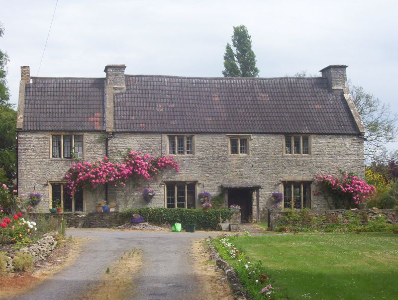
Farmhouse, now house. Dated 1624 on front door. Coursed limestone rubble with double Roman
tile roofand stone end stacks. T-shaped plan, with right-hand parlour and left-hand hall/kitchen in
symmetrical front range, with central entry opposite stair housed in rear dairy wing. 2 storeys.
Symmetrical 3-window front, with strap hinges and original lock to original plank door with
moulded ribs; round-arched relieving arches over tall 3-light stone-mullioned ogee-moulded
windows to ground floor, and hood mould over 2-light flanked by 3-light first-floor windows with
ovolo-moulded stone-mullioned windows; leaded lights. Similar wood- and stone-mullioned
windows to other elevations, and chamfered wood frame with 4-centred arch to doorway in rear
wing. Interior noted as having many original features including joinery and stair with 4 plain
diamond balusters, octagonal newel post, plain chamfered string and scratch-moulded handrail;
collar-truss roof A very good and complete example of its date, the symmetrical front and centralised
plan being an early instance of its type. Little altered, notably with removal of hoodmoulds to first
floor and 2 gabled dormers from front.
Listing NGR: ST6977876374
External links are from the relevant listing authority and, where applicable, Wikidata. Wikidata IDs may be related buildings as well as this specific building. If you want to add or update a link, you will need to do so by editing the Wikidata entry.


Other nearby listed buildings
