Approximate Location Map
Large Map »
Latitude: 52.1815 / 52°10'53"N
Longitude: 1.6141 / 1°36'50"E
OS Eastings: 647170
OS Northings: 259853
OS Grid: TM471598
Mapcode National: GBR YZN.6XK
Mapcode Global: VHM7X.XFPJ
Plus Code: 9F435JJ7+HM
Entry Name: 9 and 10, the Whinlands
Listing Date: 26 January 1995
Grade: II
Source: Historic England
Source ID: 1228553
English Heritage Legacy ID: 403101
ID on this website: 101228553
Location: Thorpeness, East Suffolk, IP16
County: Suffolk
District: East Suffolk
Civil Parish: Aldringham cum Thorpe
Built-Up Area: Thorpeness
Traditional County: Suffolk
Lieutenancy Area (Ceremonial County): Suffolk
Church of England Parish: Aldringham with Thorpe St Andrew
Church of England Diocese: St.Edmundsbury and Ipswich
Tagged with: Building
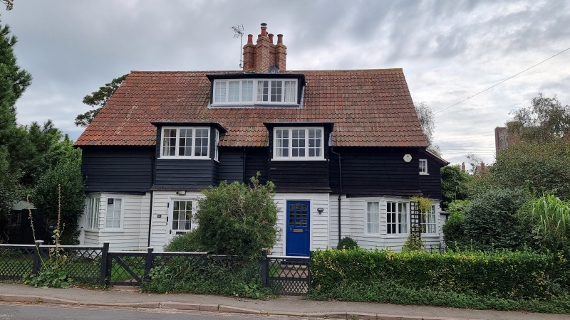
TM45NE ALDRINGHAM THE WHINLANDS
CUM THORPE Thorpeness
7/10016 Nos 9 and 10
GV II
Pair of houses. 1910-14. By Frederick Forbes Glennie as part of the Thorpeness village development for Glencairn Stuart Ogilvie. Probably concrete block with applied weatherboarding on brick plinth. Each house a mirror image, but careful asymmetry within the design. 2 storeys and attic; 2-window range of square 2-storey bays partly above eaves, and forming porches to ground floor. On ground floor to either end a square bay canted across the corner, this being formed of 2 triangular bays. Larger lean-to square section further to rear at sides. Long 6-light dormer to front. Central ridge stack with grouped flues set diagonally. INTERIOR. Not inspected. Part of a good group set between the Ogilvie Almshouses (qv) and Westbar (qv).
Historical Note: The owner of Thorpeness Estate, Glencairn Stuart Ogilvie, himself conceiving the project, designed and sketched out the whole village and commissioned the architects involved
Listing NGR: TM4717059853
External links are from the relevant listing authority and, where applicable, Wikidata. Wikidata IDs may be related buildings as well as this specific building. If you want to add or update a link, you will need to do so by editing the Wikidata entry.


Other nearby listed buildings
