Approximate Location Map
Large Map »
Latitude: 53.7179 / 53°43'4"N
Longitude: -2.0711 / 2°4'15"W
OS Eastings: 395406
OS Northings: 424616
OS Grid: SD954246
Mapcode National: GBR FTZF.DY
Mapcode Global: WHB8D.5T14
Plus Code: 9C5VPW9H+5H
Entry Name: Lobb Mill Bridge
Listing Date: 22 February 1984
Grade: II
Source: Historic England
Source ID: 1228984
English Heritage Legacy ID: 403718
ID on this website: 101228984
Location: Cross Stone, Calderdale, West Yorkshire, OL14
County: Calderdale
Civil Parish: Todmorden
Traditional County: Yorkshire
Lieutenancy Area (Ceremonial County): West Yorkshire
Church of England Parish: Todmorden St Mary
Church of England Diocese: Leeds
Tagged with: Bridge
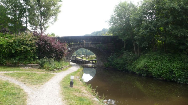
SD 92SE TODMORDEN (former M.B.) HAUGH ROAD
7/136 Lobb Mill Bridge
G.V. II
Bridge over Rochdale Canal. Early C18. Dressed stone. Single span with
horseshoe elliptical arch. Roadway slopes from south to north with answering
parapet and band.
Listing NGR: SD9540624616
External links are from the relevant listing authority and, where applicable, Wikidata. Wikidata IDs may be related buildings as well as this specific building. If you want to add or update a link, you will need to do so by editing the Wikidata entry.


Other nearby listed buildings
