Approximate Location Map
Large Map »
Latitude: 50.9163 / 50°54'58"N
Longitude: 0.4848 / 0°29'5"E
OS Eastings: 574761
OS Northings: 115918
OS Grid: TQ747159
Mapcode National: GBR PWF.HDK
Mapcode Global: FRA C6XP.6QD
Plus Code: 9F22WF8M+GW
Entry Name: 18A, High Street
Listing Date: 3 August 1961
Last Amended: 13 May 1987
Grade: II
Source: Historic England
Source ID: 1230341
English Heritage Legacy ID: 292137
ID on this website: 101230341
Location: Battle, Rother, East Sussex, TN33
County: East Sussex
District: Rother
Civil Parish: Battle
Built-Up Area: Battle
Traditional County: Sussex
Lieutenancy Area (Ceremonial County): East Sussex
Church of England Parish: Battle St Mary the Virgin
Church of England Diocese: Chichester
Tagged with: Building
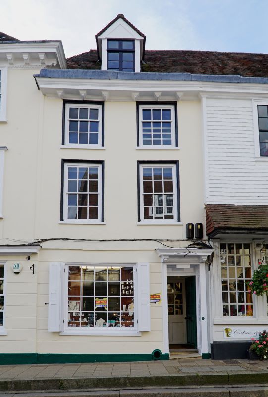
TQ 7415-7515 BATTLE HIGH STREET
(south west side)
41/15 No 18A
(formerly listed as
part of No 18)
3.8.61
GV II
Early C18. Two storeys and attic. Two windows. One dormer. Plastered front,
ground floor rusticated. Cornice above ground floor. Modillion eaves cornice.
Tiled roof. Glazing bars intact. Doorway with flat hood over and door of six
fielded panels.
Listing NGR: TQ7475315916
External links are from the relevant listing authority and, where applicable, Wikidata. Wikidata IDs may be related buildings as well as this specific building. If you want to add or update a link, you will need to do so by editing the Wikidata entry.


Other nearby listed buildings
