Approximate Location Map
Large Map »
Latitude: 50.9164 / 50°54'59"N
Longitude: 0.4845 / 0°29'4"E
OS Eastings: 574741
OS Northings: 115938
OS Grid: TQ747159
Mapcode National: GBR PWF.HB9
Mapcode Global: FRA C6XP.6M1
Plus Code: 9F22WF8M+HR
Entry Name: 20, High Street
Listing Date: 13 May 1987
Grade: II
Source: Historic England
Source ID: 1278653
English Heritage Legacy ID: 292139
ID on this website: 101278653
Location: Battle, Rother, East Sussex, TN33
County: East Sussex
District: Rother
Civil Parish: Battle
Built-Up Area: Battle
Traditional County: Sussex
Lieutenancy Area (Ceremonial County): East Sussex
Church of England Parish: Battle St Mary the Virgin
Church of England Diocese: Chichester
Tagged with: Building
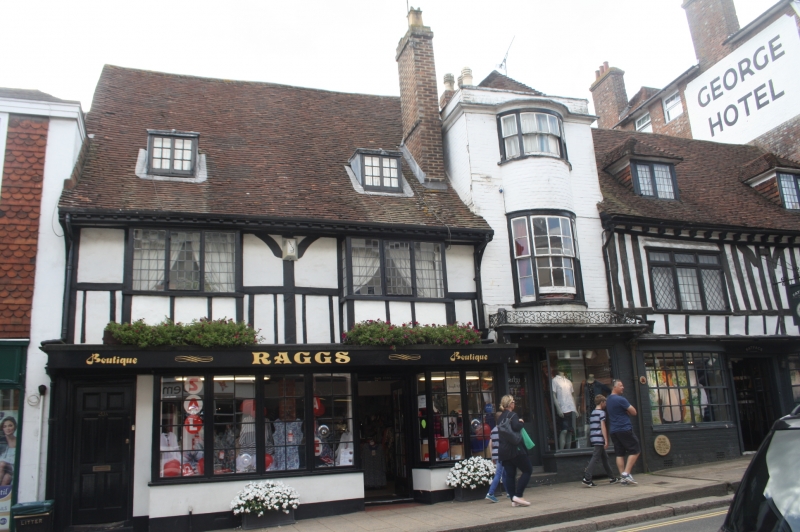
TQ 7415-7515 BATTLE HIGH STREET
(south west side)
41/17 No 20
GV II
C17 timber framed building, restored and altered. The timbering exposed with
plaster infilling on first floor. Eaves cornice. Tiled roof. Two bay windows
with small square panes on first floor. Modern shop front.
Listing NGR: TQ7474115938
External links are from the relevant listing authority and, where applicable, Wikidata. Wikidata IDs may be related buildings as well as this specific building. If you want to add or update a link, you will need to do so by editing the Wikidata entry.


Other nearby listed buildings
