Approximate Location Map
Large Map »
Latitude: 52.989 / 52°59'20"N
Longitude: -1.8305 / 1°49'49"W
OS Eastings: 411476
OS Northings: 343531
OS Grid: SK114435
Mapcode National: GBR 48Z.L17
Mapcode Global: WHCF9.V4JD
Plus Code: 9C4WX5Q9+HR
Entry Name: Milepost at Ngr SK 1148 4353
Listing Date: 30 May 1985
Grade: II
Source: Historic England
Source ID: 1230844
English Heritage Legacy ID: 405751
ID on this website: 101230844
Location: Ellastone, East Staffordshire, DE6
County: Staffordshire
District: East Staffordshire
Civil Parish: Ellastone
Traditional County: Staffordshire
Lieutenancy Area (Ceremonial County): Staffordshire
Church of England Parish: Ellastone St Peter
Church of England Diocese: Lichfield
Tagged with: Milestone
SK 14 SW
5/74
ELLASTONE C.P.
UPPER ELLASTONE
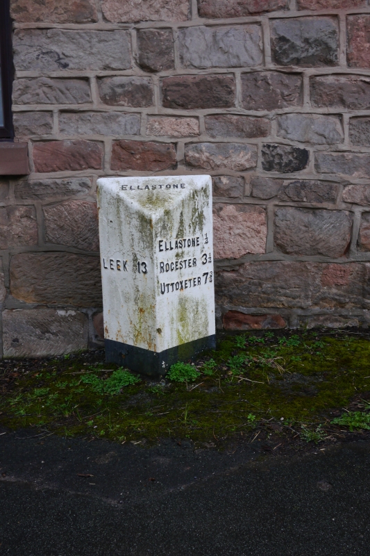
Milepost at N.G.R.SK 11484353
II
Milepost. Mid-to-late C19. Cast iron. Triangular plan with
chamfered top. Top Face: "ELLASTONE" Left hand face: "LEEK 13".
Right hand face: "ELLASTONE ¼ / ROCESTER 3¾ / UTTOXETER 7¾".
Listing NGR: SK1147643531
External links are from the relevant listing authority and, where applicable, Wikidata. Wikidata IDs may be related buildings as well as this specific building. If you want to add or update a link, you will need to do so by editing the Wikidata entry.


Other nearby listed buildings
