Approximate Location Map
Large Map »
Latitude: 53.7119 / 53°42'42"N
Longitude: -2.0977 / 2°5'51"W
OS Eastings: 393646
OS Northings: 423949
OS Grid: SD936239
Mapcode National: GBR FTSJ.N3
Mapcode Global: WHB8C.RY8R
Plus Code: 9C5VPW62+QW
Entry Name: Former Unitarian Chapel and Sunday School
Listing Date: 29 April 1982
Last Amended: 22 February 1984
Grade: II
Source: Historic England
Source ID: 1231064
English Heritage Legacy ID: 406006
ID on this website: 101231064
Location: Salford, Calderdale, West Yorkshire, OL14
County: Calderdale
Civil Parish: Todmorden
Built-Up Area: Todmorden
Traditional County: Yorkshire
Lieutenancy Area (Ceremonial County): West Yorkshire
Church of England Parish: Todmorden St Mary
Church of England Diocese: Leeds
Tagged with: Chapel Sunday school
SD 92SW TODMORDEN (former M.B.) WELLFIELD TERRACE
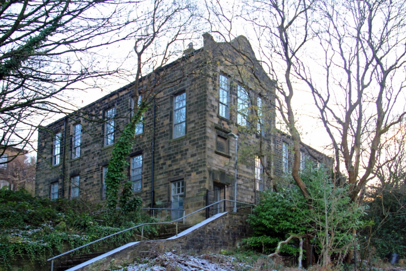
5/317 Former Unitarian Chapel
and Sunday School
(formerly listed under
29.4.82 Bank Street)
G.V. II
The original Methodist-Unitarian Todmorden Chapel 1822-24, superseded by
Gibson's 1869 Unitarian Church, Honey Holey Road (q.v.). Added cross-wing 1899.
Now forms plastics factory. Hammer-dressed stone, slate roof. Single-storey
to road, 2 to valley, west side, with the original Sunday School in lower-ground
floor. Gabled 3-storey cross-wing. 5-bay front with squared surround windows.
2 similar windows to south west end, the original Sunday school lower ground
floor fenestration retains glazing bars. Low pitch ½ hipped roof with console
brackets spaced to gutter-eaves cornice. Chamfered rusticated quoins. The
cross-wing has a shaped gable with kneelers. Doorway for sunday school entrance
has triple keystone over which is inscribed tablet set within a recess which
reads: TO THE MEMORY OF SAMUEL, JOHN, AND JOSHUA FIELDEN, Constant Benefactors
of THE UNITARIAN CHURCH AND SCHOOL This stone was laid by S. ALFRED STEINTHAL
June 17th 1899
3 large windows to lst floor. 5-bay return, and 5-bay main range all with
windows with plain stone surrounds. Gable to south has inserted loading bay
c.1980.
Listing NGR: SD9364723950
External links are from the relevant listing authority and, where applicable, Wikidata. Wikidata IDs may be related buildings as well as this specific building. If you want to add or update a link, you will need to do so by editing the Wikidata entry.


Other nearby listed buildings
