Approximate Location Map
Large Map »
Latitude: 51.8522 / 51°51'8"N
Longitude: -1.0724 / 1°4'20"W
OS Eastings: 463985
OS Northings: 217479
OS Grid: SP639174
Mapcode National: GBR 9ZB.ZMP
Mapcode Global: VHCXC.CPDY
Plus Code: 9C3WVW2H+V2
Entry Name: Barn Approximately 100 Metres North West of Brown's Place
Listing Date: 9 December 1987
Grade: II
Source: Historic England
Source ID: 1233002
English Heritage Legacy ID: 408426
ID on this website: 101233002
Location: Piddington, Cherwell, Oxfordshire, OX25
County: Oxfordshire
District: Cherwell
Civil Parish: Piddington
Built-Up Area: Piddington
Traditional County: Oxfordshire
Lieutenancy Area (Ceremonial County): Oxfordshire
Church of England Parish: Piddington
Church of England Diocese: Oxford
Tagged with: Barn
SP61NW PIDDINGTON ARNCOTT ROAD
(North side)
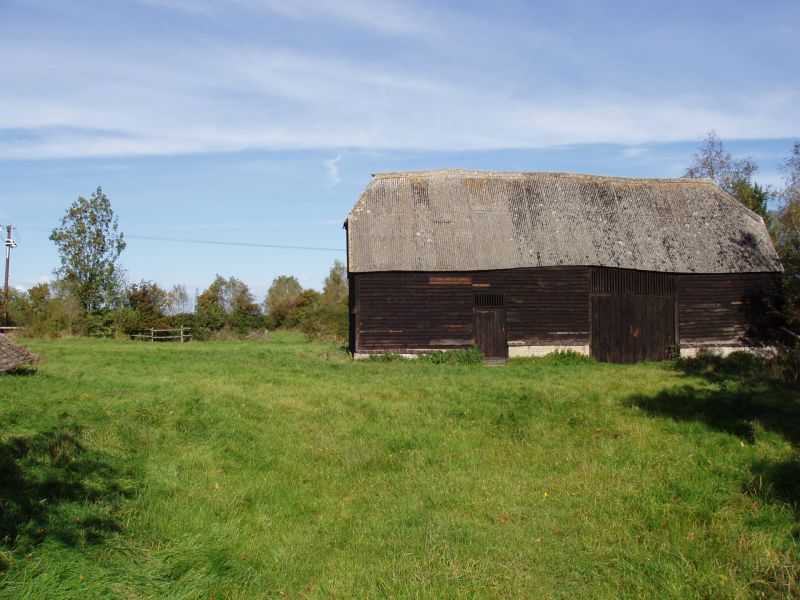
11/128 Barn approx. l00m. NW of
Brown's Piece
GV II
Barn. C17, possibly earlier. Weatherboarded timber framing on a limestone-rubble
plinth; corrugated-asbestos roof. 3-bay plan with added bay. Larger section to
right has central double doors but no rear doors; left bay and added bay have
smaller doors. Half-hipped roof. Interior: roof has one row of clasped purlins
supported on heavy curved struts; walls have some heavy framing but are partly
rebuilt; added bay also has some heavy timbers. Included for group value.
Listing NGR: SP6398517479
External links are from the relevant listing authority and, where applicable, Wikidata. Wikidata IDs may be related buildings as well as this specific building. If you want to add or update a link, you will need to do so by editing the Wikidata entry.


Other nearby listed buildings
