Approximate Location Map
Large Map »
Latitude: 51.854 / 51°51'14"N
Longitude: -1.0711 / 1°4'15"W
OS Eastings: 464074
OS Northings: 217670
OS Grid: SP640176
Mapcode National: GBR 9ZC.L1X
Mapcode Global: VHCXC.DN3M
Plus Code: 9C3WVW3H+HH
Entry Name: 33, Lower End
Listing Date: 9 December 1987
Grade: II
Source: Historic England
Source ID: 1276801
English Heritage Legacy ID: 408428
ID on this website: 101276801
Location: Piddington, Cherwell, Oxfordshire, OX25
County: Oxfordshire
District: Cherwell
Civil Parish: Piddington
Built-Up Area: Piddington
Traditional County: Oxfordshire
Lieutenancy Area (Ceremonial County): Oxfordshire
Church of England Parish: Piddington
Church of England Diocese: Oxford
Tagged with: Building Thatched cottage
SP61NW
11/130
PIDDINGTON
LOWER END
(West side)
No 33
II
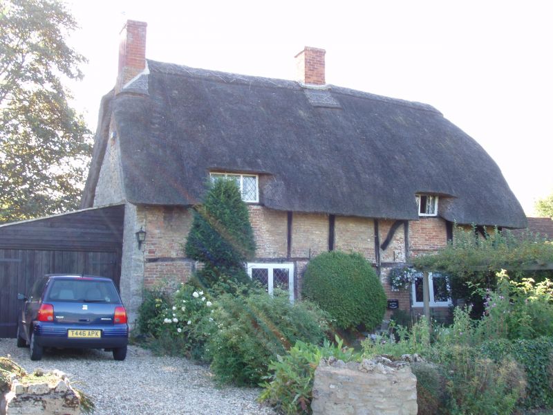
Small house. Late C16/early C17. Timber framing with brick: infill; limestone
rubble: thatch roof with brick stacks. 2-unit lobby-entry plan. One storey plus
attic, irregular front has a central doorway, flanking 2-light casements, and
has two 3-light dormers with old lattice glazing; left bay has a rubble plinth
and gable wall; right bay has straight and ogee bracing. Roof has stacks to left
gable end in line with entrance. Interior not inspected. Right bay is probably
slightly earlier.
Listing NGR: SP6407417670
External links are from the relevant listing authority and, where applicable, Wikidata. Wikidata IDs may be related buildings as well as this specific building. If you want to add or update a link, you will need to do so by editing the Wikidata entry.


Other nearby listed buildings
