Approximate Location Map
Large Map »
Latitude: 52.7643 / 52°45'51"N
Longitude: -0.8898 / 0°53'23"W
OS Eastings: 475011
OS Northings: 319104
OS Grid: SK750191
Mapcode National: GBR BNW.PVW
Mapcode Global: WHFK0.9SK5
Plus Code: 9C4XQ476+P3
Entry Name: Lady Wilton's Bridge and Adjacent Former Horse Wash
Listing Date: 12 October 1976
Grade: II
Source: Historic England
Source ID: 1235536
English Heritage Legacy ID: 426201
ID on this website: 101235536
Location: Melton Mowbray, Melton, Leicestershire, LE13
County: Leicestershire
District: Melton
Electoral Ward/Division: Melton Warwick
Parish: Non Civil Parish
Built-Up Area: Melton Mowbray
Traditional County: Leicestershire
Lieutenancy Area (Ceremonial County): Leicestershire
Church of England Parish: Melton Mowbray Team
Church of England Diocese: Leicester
Tagged with: Architectural structure
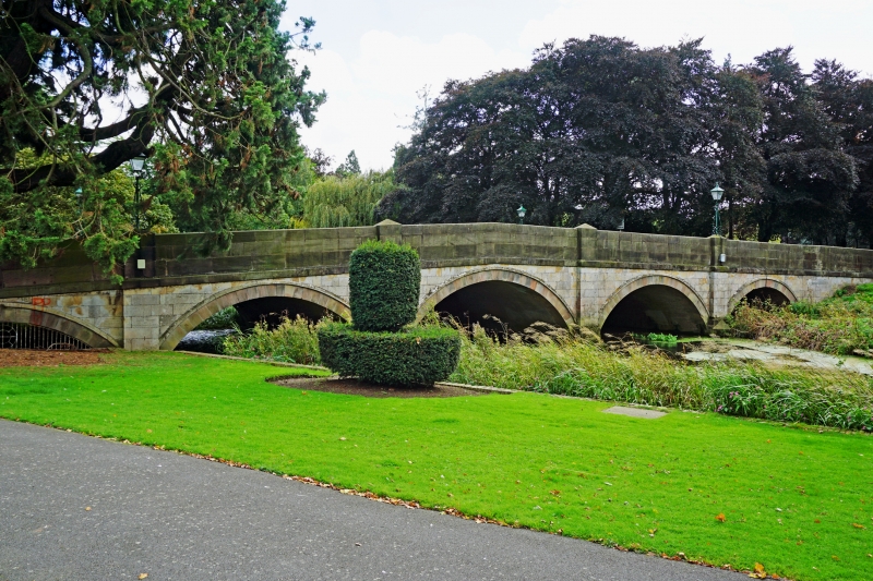
1.
5305 LEICESTER ROAD
Lady Wilton's Bridge
and adjacent former
Horse Wash
SK 7519 SW 1/125
SK 7419 SE 1/125
II GV
2.
Ashlar with parapet rising towards centre, band below. 5 segmental arches with
cutwaters and piers between arches, these terminate in pyramidal caps on parapet.
Arches graduated in size to centre largest arch. Wrought iron scrolled lamp brackets
at each end. Shown on earlier C19 maps as 'Eye Kettleby Bridge'. Former horse-wash
flanked by rusticated stone walls and with cobbled surface partly exposed, leads
down to river from Leicester Street. End pier to wall, ashlar with moulded cap
and cornice.
Lady Wilton's Bridge and the Horse Wash, form a group with Egerton Lodge, its raised
terrace, the archway in its eastern garden wall, Wilton Street and with Nos 29 to
33 (odd) High Street the latter of local interest).
Listing NGR: SK7501119104
External links are from the relevant listing authority and, where applicable, Wikidata. Wikidata IDs may be related buildings as well as this specific building. If you want to add or update a link, you will need to do so by editing the Wikidata entry.


Other nearby listed buildings
