Latitude: 50.4312 / 50°25'52"N
Longitude: -3.686 / 3°41'9"W
OS Eastings: 280351
OS Northings: 60391
OS Grid: SX803603
Mapcode National: GBR QM.T6QH
Mapcode Global: FRA 375X.7V1
Plus Code: 9C2RC8J7+FJ
Entry Name: 56, Fore Street
Listing Date: 14 November 1969
Grade: II
Source: Historic England
Source ID: 1235942
English Heritage Legacy ID: 426806
ID on this website: 101235942
Location: Totnes, South Hams, Devon, TQ9
County: Devon
District: South Hams
Civil Parish: Totnes
Built-Up Area: Totnes
Traditional County: Devon
Lieutenancy Area (Ceremonial County): Devon
Church of England Parish: Totnes St Mary
Church of England Diocese: Exeter
Tagged with: Building
1. 5180 FORE STREET (South Side) ----------- No 56 SX 8060 SW 2/32A 14.11.69.
II GV
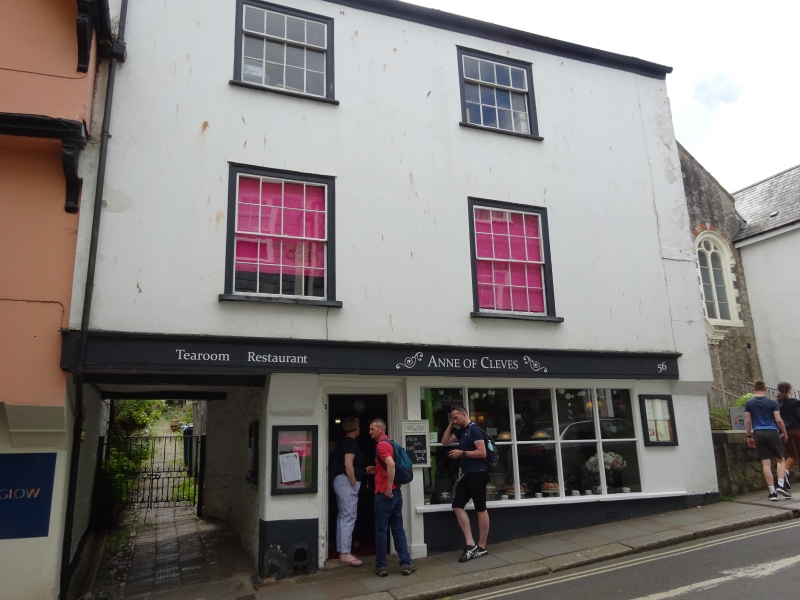
2. Later C16 or early C17 merchant's house of the "deux corps de batiments" type. Retains its gallery. The former back block is now No 1 Atherton Lane. Rebuilt early C19 extending over Atherton Lane at 1st floor level. 3 storeys. 2 windows. Welsh slate roof with red brick stacks. Retains masonry party wall corbelled at 1st floor level for former jetty. Plastered timber framed front with 1st floor jetty. 1st and 2nd floor with architraved sash windows with glazing bars. Modern ground floor shop window and doorway. Former architraved house doorway converted for use as window.
Listing NGR: SX8035160391
External links are from the relevant listing authority and, where applicable, Wikidata. Wikidata IDs may be related buildings as well as this specific building. If you want to add or update a link, you will need to do so by editing the Wikidata entry.


Other nearby listed buildings