Approximate Location Map
Large Map »
Latitude: 52.5953 / 52°35'43"N
Longitude: -0.678 / 0°40'40"W
OS Eastings: 489647
OS Northings: 300547
OS Grid: SK896005
Mapcode National: GBR DTY.9DH
Mapcode Global: WHGM6.K1C5
Plus Code: 9C4XH8WC+4R
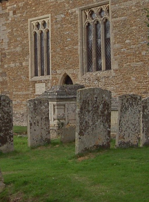
Entry Name: Monument in Churchyard 1 Metre to South East of Chancel Door
Listing Date: 6 July 1987
Grade: II
Source: Historic England
Source ID: 1236494
English Heritage Legacy ID: 427492
ID on this website: 101236494
Location: St Andrew's Church, Glaston, Rutland, LE15
County: Rutland
Civil Parish: Glaston
Traditional County: Rutland
Lieutenancy Area (Ceremonial County): Rutland
Church of England Parish: Glaston St Andrew
Church of England Diocese: Peterborough
Tagged with: Monument
GLASTON CHURCH LANE
SK 8800-8900
7/32
Monument in
churchyard 1 m to
SE of chancel
door.
GV II
Tomb chest. Early C19. Limestone ashlar. Panelled sides with illegible
inscriptions; recessed corners with rectangular balusters; moulded base and
cornice lid; stepped and coved top with missing central ornament.
Listing NGR: SK8964700547
External links are from the relevant listing authority and, where applicable, Wikidata. Wikidata IDs may be related buildings as well as this specific building. If you want to add or update a link, you will need to do so by editing the Wikidata entry.


Other nearby listed buildings
