Latitude: 52.057 / 52°3'25"N
Longitude: 1.1545 / 1°9'16"E
OS Eastings: 616362
OS Northings: 244542
OS Grid: TM163445
Mapcode National: GBR TMW.4PY
Mapcode Global: VHLBS.YKQG
Plus Code: 9F433543+QR
Entry Name: 1A, St Stephens Lane
Listing Date: 15 December 1977
Grade: II
Source: Historic England
Source ID: 1236891
English Heritage Legacy ID: 427976
ID on this website: 101236891
Location: Ipswich, Suffolk, IP1
County: Suffolk
District: Ipswich
Electoral Ward/Division: Alexandra
Parish: Non Civil Parish
Built-Up Area: Ipswich
Traditional County: Suffolk
Lieutenancy Area (Ceremonial County): Suffolk
Church of England Parish: Ipswich St Mary-le-Tower
Church of England Diocese: St.Edmundsbury and Ipswich
Tagged with: Building
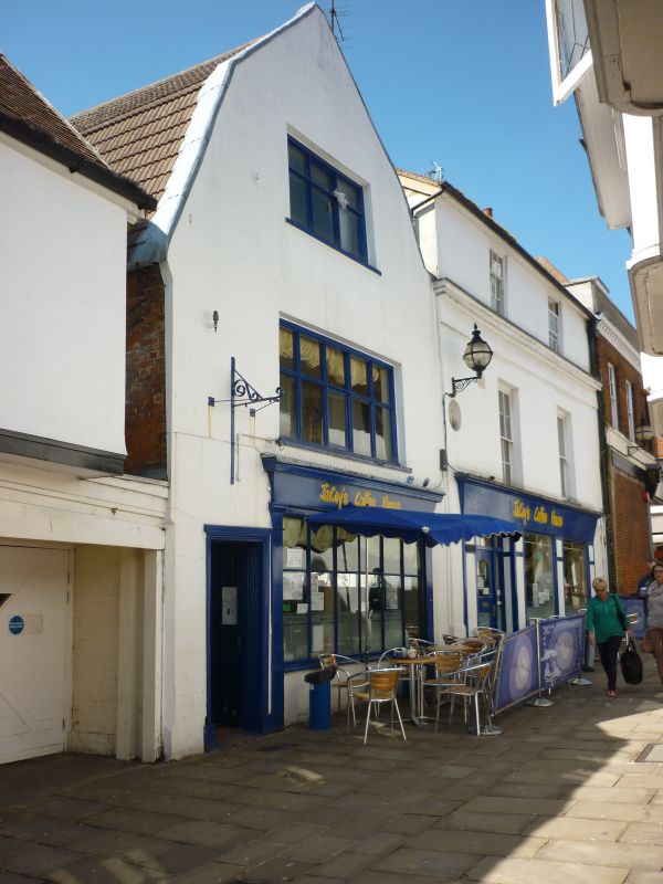
ST STEPHENS LANE
1.
5379 (West Side)
No 1A
TM 1644 NW 1/483
II GV
2.
A late C18 or early C19 stucco fronted building lined as ashlar with a C20 shop
front on the ground storey. 3 storeys. 2 window range, double-hung sashes with
glazing bars. A stone moulded cornice extends between the 1st and 2nd storeys.
Listing NGR: TM1636244542
External links are from the relevant listing authority and, where applicable, Wikidata. Wikidata IDs may be related buildings as well as this specific building. If you want to add or update a link, you will need to do so by editing the Wikidata entry.


Other nearby listed buildings