Approximate Location Map
Large Map »
Latitude: 53.8278 / 53°49'39"N
Longitude: -1.6438 / 1°38'37"W
OS Eastings: 423541
OS Northings: 436890
OS Grid: SE235368
Mapcode National: GBR JSY5.XL
Mapcode Global: WHC9B.Q1FX
Plus Code: 9C5WR9H4+4F
Entry Name: New Laithes Manor House
Listing Date: 19 October 1962
Last Amended: 7 April 1988
Grade: II
Source: Historic England
Source ID: 1240011
English Heritage Legacy ID: 438082
ID on this website: 101240011
Location: Newlay, Leeds, West Yorkshire, LS18
County: Leeds
Civil Parish: Horsforth
Built-Up Area: Horsforth
Traditional County: Yorkshire
Lieutenancy Area (Ceremonial County): West Yorkshire
Church of England Parish: Horsforth St Margaret
Church of England Diocese: Leeds
Tagged with: House
SE 23 NW
8/139
HORSFORTH
NEW LAITHES ROAD, LS 18 (west side)
New Laithes Manor House
(Formerly listed as New Laithes Grange)
19.10.1962
II
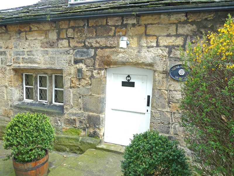
Manor house, now house. C17 or earlier, remodelled and extended in C18 and C19. Coursed sandstone rubble with quoins, roof on two levels, of stone slate and slate respectively; some internal timber framing. Long range with four-bay aisled main range, with one-bay cottage on same axis at left end, and projecting one-bay wing at east end.
Two storeys; main facade set back (perhaps moved back in C18 or C19), now stuccoed and painted white, has a C19 Tudor-arched doorway at the right-hand end, with a moulded cornice over it, on each floor two sixteen-pane sashed windows with raised plain surrounds and between these a single-light window, the upper with a hoodmould; ridge chimney in line with these. To the left, the cottage projects slightly, and has one square window on each floor. To the right, the projecting east wing has a recessed mullioned window formerly of four lights but now two, lacking the first and third mullions, and a square window above; and the roof is ridged in parallel with that of the main range, but on a lower level and forward of it. The right return wall of this wing has a large external chimney stack towards the front corner, C18 windows of two lights at ground floor and one light above; and a plain doorway and single-storey addition to the rear. The east gable of the main range above this wing has an exposed king-post truss with A-struts. Rear of main range, single-storey under catslide roof, has C17 features including a Tudor-arched doorway near the centre, a three-light mullioned window to the left and a small cross-window beyond this; patched masonry and a chimney to the right; in the left end wall of the outshut a cross-window at ground floor and two-light window above; in the right-hand end of the outshut a recessed five-light mullioned window; an inserted eye-brow dormer in the outshut roof. Rear of cottage at west end of less interest.
Interior: main range has four-bay aisle arcade of jowelled posts, including posts at the end wall of this range; some blocked mortices for braces to tie-beams; similar evidence of timber-framed construction at first floor of east wing, which has exposed wall posts, wall-plates and tie-beams, with braces from the posts; in the main range a deeply-chamfered spine-beam with matching sleeve extending approximately 2 metres from present chimney-breast (probably concealing a scarf-joint) and suggesting a former firehood bressumer; much panelling of C17 period or earlier, including some linen-fold pattern with carved crosses; in rear wall of outshut, a large segmental arched fireplace with chamfered surround.
In east wing, moulded plaster roundel in the ceiling, containing a four-point star; and a Tudor-arched fireplace on each floor.
History: occupied by Pollard family, (purchased by them in 1566) until c.1800. Development of the building complex and obscure, but see RCHM Report by C. Giles, 1981, West Yorks. Archaeological Unit, Wakefield.
Listing NGR: SE2354136890
External links are from the relevant listing authority and, where applicable, Wikidata. Wikidata IDs may be related buildings as well as this specific building. If you want to add or update a link, you will need to do so by editing the Wikidata entry.


Other nearby listed buildings
