Approximate Location Map
Large Map »
Latitude: 53.8223 / 53°49'20"N
Longitude: -1.6386 / 1°38'18"W
OS Eastings: 423889
OS Northings: 436287
OS Grid: SE238362
Mapcode National: GBR KS07.1K
Mapcode Global: WHC9B.S6X2
Plus Code: 9C5WR9C6+WH
Entry Name: Whitecote House with Adjoining Ranges
Listing Date: 5 August 1976
Grade: II
Source: Historic England
Source ID: 1375483
English Heritage Legacy ID: 466381
ID on this website: 101375483
Location: Newlay, Leeds, West Yorkshire, LS13
County: Leeds
Electoral Ward/Division: Bramley and Stanningley
Parish: Non Civil Parish
Traditional County: Yorkshire
Lieutenancy Area (Ceremonial County): West Yorkshire
Church of England Parish: Bramley St Peter
Church of England Diocese: Leeds
Tagged with: House
LEEDS
SE23NW POLLARD LANE, Whitecote
714-1/5/1239 (West side (off))
05/08/76 Whitecote House with adjoining
ranges
GV II
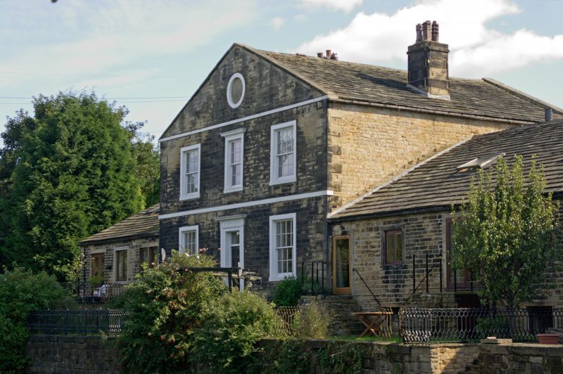
Large house with attached warehouses. Late C18 with
restoration and conversion to residential c1990. Coursed
squared hammer-dressed gritstone, stone slate roofs.
House of 2 storeys with attic, 3 bays, quoins; flanking
single-storey wings, of 2 bays, converted to house, on N side;
of 7 bays with ruined 2-storey end bay to S; cellars
throughout.
House: facade to canal has stone steps up to panelled door
with overlight in architrave with cornice and fluted frieze;
restored 16-pane sashes in plain surrounds, blocked round
window in gable, architrave to 1st-floor centre; band at floor
and eaves levels; square ashlar stack at centre of each roof
slope. Rear: central doorway in plain surround, tall
round-headed stair window above, 16-pane sashes, round-arched
window in gable.
N wing: new fenestration obscures arrangement of window and
loading door with steps down to cellar on canal side, arched
openings low down on left return.
The S wing retains original doorway in plain surround close to
house, left, C20 windows, cellar openings below. Raised ground
level obscures original openings in the ruined bay but lintel
on left return where the bay projects slightly from the line
of the S wing suggests cellar access at this point and similar
on the S wall.
INTERIOR: house not examined; cellar below N wing has
stone-flagged floor and cast-iron columns supporting timber
cross beams, blocked round-arched recesses suggest blocked
access to house cellars. S wing: roof structure of 6 pegged
double queen-post trusses, spine wall supporting cross beams
which span approx 12m.
An important canalside range possibly associated with local
brewery ownership; the warehouse doorway positions correspond
to the narrow gates in the canal-side railings (qv).
Listing NGR: SE2388936287
External links are from the relevant listing authority and, where applicable, Wikidata. Wikidata IDs may be related buildings as well as this specific building. If you want to add or update a link, you will need to do so by editing the Wikidata entry.


Other nearby listed buildings
