Latitude: 51.3209 / 51°19'15"N
Longitude: 0.897 / 0°53'49"E
OS Eastings: 601957
OS Northings: 161957
OS Grid: TR019619
Mapcode National: GBR SW3.5L8
Mapcode Global: VHKJW.H2K8
Plus Code: 9F328VCW+8Q
Entry Name: Warehouse About 15 Metres North East of Provender Mill (Gilletts Limited)
Listing Date: 27 September 1989
Grade: II
Source: Historic England
Source ID: 1240512
English Heritage Legacy ID: 438957
ID on this website: 101240512
Location: Faversham, Swale, Kent, ME13
County: Kent
District: Swale
Civil Parish: Faversham
Built-Up Area: Faversham
Traditional County: Kent
Lieutenancy Area (Ceremonial County): Kent
Tagged with: Warehouse
FAVERSHAM STANDARD QUAY
TR 0161 NE
F 100 1/375 Warehouse about 15
metres north east of
Provender Mill
(Gilletts Ltd)
Interior inspected
GV
II
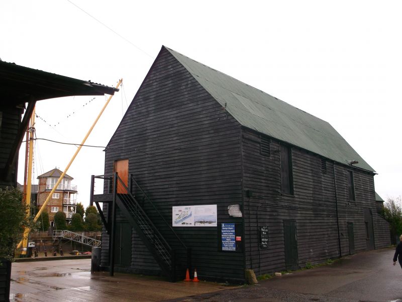
Warehouse. C18 and extended early C19. Timber framed and part underbuilt
with red brick on ground floor. Weather boarded with corrugated iron roofs.
Original portion of 2 storeys with hipped roof, the south-east elevation with
single boarded door on ground floor, the quayside elevation with red brick
ground floor with casement window and boarded door and boarded loft door over.
Extended to north east by early C19 block with gabled roof and blocked loft
door to quayside; lean-to on roadside (south-east). Large curbing stones at
the corners of both builds. Interior: the C18 range is clearly of earlier
build than the adjacent warehouses, the framing and proportions of the structure
are on a smaller scale and make use of squarer section timbers with larger,
straight braces. A key element in the rare group of quayside warehouses
preserved here, marked in situ on the 1841 tithe Map and all grouping with
Provender Mill (Grade II*) opposite.
Listing NGR: TR0195761957
External links are from the relevant listing authority and, where applicable, Wikidata. Wikidata IDs may be related buildings as well as this specific building. If you want to add or update a link, you will need to do so by editing the Wikidata entry.


Other nearby listed buildings