Approximate Location Map
Large Map »
Latitude: 51.2801 / 51°16'48"N
Longitude: 1.0806 / 1°4'50"E
OS Eastings: 614943
OS Northings: 157950
OS Grid: TR149579
Mapcode National: GBR TY2.Q1N
Mapcode Global: VHLGM.P24Z
Plus Code: 9F3373JJ+27
Entry Name: 1, Palace Street
Listing Date: 7 September 1973
Grade: II
Source: Historic England
Source ID: 1241431
English Heritage Legacy ID: 440491
ID on this website: 101241431
Location: Canterbury, Kent, CT1
County: Kent
District: Canterbury
Electoral Ward/Division: Westgate
Parish: Non Civil Parish
Built-Up Area: Canterbury
Traditional County: Kent
Lieutenancy Area (Ceremonial County): Kent
Tagged with: Building
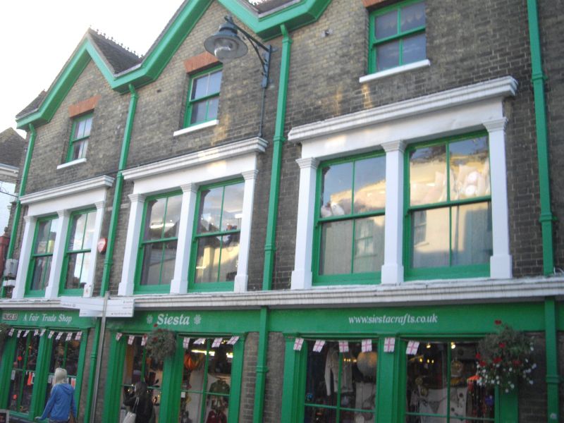
1.
944 PALACE STREET
(West Side)
No 1
TR 1457 NE 4/641
II GV
2.
Mid to later C19. 3 storeys buff brick. Tiled roof with 4 gablets. 4 sashes
with verticals only. 1st floor has double-hung sashes set in stone architraves
with cornices and pilasters. Ground floor has stone stringcourse. Grade II
for group value.
Nos 1, 2 and Nos 4 to 8 (consec) form a group.
Listing NGR: TR1493657953
External links are from the relevant listing authority and, where applicable, Wikidata. Wikidata IDs may be related buildings as well as this specific building. If you want to add or update a link, you will need to do so by editing the Wikidata entry.


Other nearby listed buildings
