Latitude: 51.5813 / 51°34'52"N
Longitude: 0.1837 / 0°11'1"E
OS Eastings: 551400
OS Northings: 189194
OS Grid: TQ514891
Mapcode National: GBR SK.2YV
Mapcode Global: VHHN7.4JH4
Plus Code: 9F32H5JM+GF
Entry Name: Havering Town Hall
Listing Date: 17 February 1999
Grade: II
Source: Historic England
Source ID: 1245551
English Heritage Legacy ID: 472993
Also known as: Romford Town Hall
ID on this website: 101245551
Location: Romford, Havering, London, RM1
County: London
District: Havering
Electoral Ward/Division: Romford Town
Parish: Non Civil Parish
Built-Up Area: Havering
Traditional County: Essex
Lieutenancy Area (Ceremonial County): Greater London
Church of England Parish: Romford St Edward Confessor
Church of England Diocese: Chelmsford
Tagged with: City hall Seat of local government
TQ 58 NW MAIN ROAD
940/10/10009 Havering Town Hall
- II
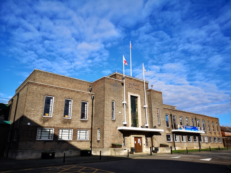
Town Hall. Built as Romford Town Hall, designed in 1935 by architects H R Collins and A E O Geens in International Moderne style and extended by three bays to the south west in 1960 in matching style and materials. The 1988 south eastern wing is not of special interest. Steel-framed with Leicester silver grey facing bricks and Swanage stone facings and plinth. Flat roof. Plan was L-shaped and a proposed refreshment hall and assembly hall was never built. Two storeys, with partial set back attic storey to main front; 14 bays to main front and 17 bays to rear wing. Windows are metal-framed casements, ta1l narrow windows to first floor and shorter tripartite windows to ground floor. The main feature of the front elevation is the projecting full-height entrance hall with tall central staircase windows and, smaller narrow flanking sidelights. This incorporates three flagpoles. Under a flat canopy is the stone architrave to doorcase with double oak doors flanked by sidelights with decorative metal grilles and two square stone plinths. To the right is a partial attic storey which was originally a caretaker's flat and outside four windows is a balcony with metal railings. The L-wing has mainly tripartite windows apart from tall staircase windows and a stone surround to a rear entrance. The south western extension has matching brickwork, windows and stone entrance. INTERIOR: Staircase Hall has large Imperial staircase with metal handrails, hall lined in Bath stone with rusticated courses and columned entrances to Council Chamber and Committee corridor. Council Chamber retains Austrian oak Public Gallery with giant piers, dado panelling and dais and large skylight to ceiling. Committee Room One retains oak panelling and folding doors. Committee Room Two retains folding doors and probably original panelling beneath later C20 panelling. Former Rates Office on ground floor retains original steps under later floor.
Original corridors and staircases and some small offices survive. ["The Architect and Building news" 1.10.37.]
Listing NGR: TQ5140089194
External links are from the relevant listing authority and, where applicable, Wikidata. Wikidata IDs may be related buildings as well as this specific building. If you want to add or update a link, you will need to do so by editing the Wikidata entry.


Other nearby listed buildings