Approximate Location Map
Large Map »
Latitude: 53.5004 / 53°30'1"N
Longitude: -2.3806 / 2°22'50"W
OS Eastings: 374852
OS Northings: 400482
OS Grid: SD748004
Mapcode National: GBR CWTY.DX
Mapcode Global: WH988.D8MV
Plus Code: 9C5VGJ29+5Q
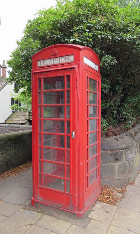
Entry Name: K6 Telephone Kiosk
Listing Date: 28 October 1987
Grade: II
Source: Historic England
Source ID: 1245624
English Heritage Legacy ID: 210996
ID on this website: 101245624
Location: Worsley, Salford, Greater Manchester, M28
County: Salford
Electoral Ward/Division: Worsley
Parish: Non Civil Parish
Built-Up Area: Eccles
Traditional County: Lancashire
Lieutenancy Area (Ceremonial County): Greater Manchester
Church of England Parish: Worsley St Mark
Church of England Diocese: Manchester
Tagged with: K6 telephone box
SD 70 SW WORSLEY ROAD
1479/1/1 K6 Telephone Kiosk
28.10.1987 II
Telephone kiosk. Type K6. Designed 1935 by Sir Giles Gilbert Scott. Made by Various contractors. Cast iron. Square kiosk with domed roof. Unperforated crowns to top panels and margin glazing to windows and door.
Listing NGR: SD7485200482
External links are from the relevant listing authority and, where applicable, Wikidata. Wikidata IDs may be related buildings as well as this specific building. If you want to add or update a link, you will need to do so by editing the Wikidata entry.


Other nearby listed buildings
