Latitude: 52.9517 / 52°57'6"N
Longitude: -1.1434 / 1°8'36"W
OS Eastings: 457647
OS Northings: 339711
OS Grid: SK576397
Mapcode National: GBR LQQ.L1
Mapcode Global: WHDGZ.D2RH
Plus Code: 9C4WXV24+MJ
Entry Name: Birkin Building
Listing Date: 12 July 1972
Last Amended: 30 November 1995
Grade: II
Source: Historic England
Source ID: 1246290
English Heritage Legacy ID: 454867
ID on this website: 101246290
Location: Lace Market, Nottingham, Nottinghamshire, NG1
County: City of Nottingham
Electoral Ward/Division: Bridge
Parish: Non Civil Parish
Built-Up Area: Nottingham
Traditional County: Nottinghamshire
Lieutenancy Area (Ceremonial County): Nottinghamshire
Church of England Parish: Nottingham St Peter with St James
Church of England Diocese: Southwell and Nottingham
Tagged with: Building
NOTTINGHAM
SK5739NE BROADWAY
646-1/21/59 (South side)
12/07/72 Birkin Building
(Formerly Listed as:
BROADWAY
Nos 2-6 (even) and Warehouse
occupied by John Lees & Co.)
GV II
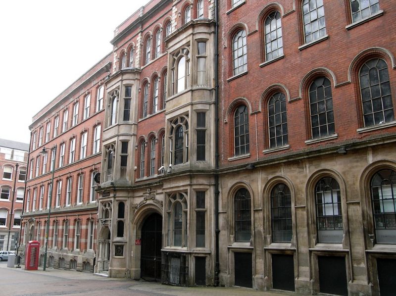
Lace warehouse, now club and offices. Dated 1855. By TC Hine
of Nottingham for Richard Birkin, lace manufacturer. Built by
Garland & Holland. Restored and converted c1987. Red brick,
with ashlar ground floor and dressings. Roof not visible
behind rendered coped parapet. Italianate style.
EXTERIOR: plinth, ground floor cornice, string course, eaves
cornice. 4 storeys; 8 x 3 windows. L-plan, following the curve
of the street. Windows are mainly original round-arched lights
with stone mullions, glazing bars and hood moulds. Ground
floor windows have moulded surrounds and aprons.
Main entrance front, facing east, has a central projecting
entrance bay with a canted tower porch, 3 storeys, with double
doors. Above, bay windows, 3 lights. Above again, a double
window. On each side, single windows on each floor. To right a
rounded corner, single windows, and to left, a rounded concave
corner with 2 windows.
Left return, facing north, has to left an entrance bay with a
central segment-arched cart entrance with an inscribed ribbon
above it. Above, triple windows on each floor. Under the arch,
a reset 2-light window, C12, from St Mary's Church, and a
plaque with the Plumptre arms. On each side, canted bay
windows, 3 storeys, 3 lights, the left one with a shouldered
double doorway and shafts. Above them, double windows. To
right, a range with regular fenestration, 5 windows.
INTERIOR: refitted c1987, has cast-iron columns to wooden
floor beams.
This building stands on the site of Plumptre House, 1730, by
Colen Campbell, demolished 1853. A major example of Hine's
commercial buildings.
(The Buildings of England: Pevsner N: Nottinghamshire: London:
1979-: 218; Get to know Nottingham: Brand K: Thomas Chambers
Hine; an architect of Victorian Nottingham: Nottingham:
10-12).
Listing NGR: SK5764739711
External links are from the relevant listing authority and, where applicable, Wikidata. Wikidata IDs may be related buildings as well as this specific building. If you want to add or update a link, you will need to do so by editing the Wikidata entry.


Other nearby listed buildings