Approximate Location Map
Large Map »
Latitude: 52.9515 / 52°57'5"N
Longitude: -1.143 / 1°8'34"W
OS Eastings: 457675
OS Northings: 339695
OS Grid: SK576396
Mapcode National: GBR LQQ.N2
Mapcode Global: WHDGZ.D2YL
Plus Code: 9C4WXV24+JQ
Entry Name: 1, Kayes Walk
Listing Date: 30 November 1995
Grade: II
Source: Historic England
Source ID: 1254534
English Heritage Legacy ID: 457414
ID on this website: 101254534
Location: Lace Market, Nottingham, Nottinghamshire, NG1
County: City of Nottingham
Electoral Ward/Division: Bridge
Parish: Non Civil Parish
Built-Up Area: Nottingham
Traditional County: Nottinghamshire
Lieutenancy Area (Ceremonial County): Nottinghamshire
Church of England Parish: Nottingham St Peter with St James
Church of England Diocese: Southwell and Nottingham
Tagged with: Building
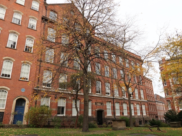
NOTTINGHAM
SK5739NE KAYES WALK
646-1/21/300 (North side)
No.1
GV II
Warehouse, now offices. c1853-60, raised late C19, restored
and converted late C20. Red brick and ashlar, with ashlar
dressings and slate roof.
Ashlar basement, sill bands, bracketed cornice, coped parapet.
4 storeys plus basement and attics; 4 window range. Windows
are segment-arched plain sashes with projecting surrounds and
keystones. Attic is topped with a coped gable with finials,
containing a roundel with keystones. Basement has 4
segment-arched openings with vermiculated keystones. To right,
a moulded segment-arched doorcase with half-glazed double
doors and stone mullioned overlight.
INTERIOR: ground floor has fluted cast-iron columns. Strutted
king post roofs towards the front, common rafter roofs towards
the rear, with collars carried on cast-iron brackets.
(Nottingham Industrial Archaeological Society Journal:
Oldfield G: Nottingham: 1983-: 3-7; Salmon's Map of
Nottingham: Nottingham: 1861-).
Listing NGR: SK5767539695
External links are from the relevant listing authority and, where applicable, Wikidata. Wikidata IDs may be related buildings as well as this specific building. If you want to add or update a link, you will need to do so by editing the Wikidata entry.


Other nearby listed buildings
