Approximate Location Map
Large Map »
Latitude: 53.1333 / 53°7'59"N
Longitude: -1.5532 / 1°33'11"W
OS Eastings: 429988
OS Northings: 359666
OS Grid: SK299596
Mapcode National: GBR 58X.J49
Mapcode Global: WHCDP.3HMS
Plus Code: 9C5W4CMW+8P
Entry Name: The Rectory
Listing Date: 22 June 1950
Grade: II
Source: Historic England
Source ID: 1247861
English Heritage Legacy ID: 429241
ID on this website: 101247861
Location: Old Matlock, Derbyshire Dales, Derbyshire, DE4
County: Derbyshire
District: Derbyshire Dales
Civil Parish: Matlock Town
Built-Up Area: Matlock
Traditional County: Derbyshire
Lieutenancy Area (Ceremonial County): Derbyshire
Church of England Parish: Matlock St Giles
Church of England Diocese: Derby
Tagged with: Clergy house
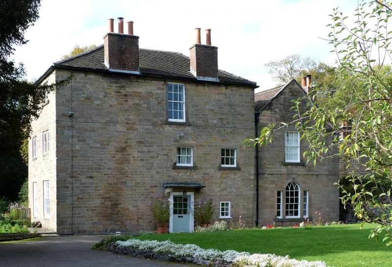
1. CHURCH STREET
1390 MATLOCK
No 112
(The Rectory)
SK 2959 4/31 22.6.50.
II
2.
Late C18. Ashlar. 3 storeys; 2 sash windows in plain architraves; door
in slain wooden architrave with hood on consoles; hipped tiled roof. A
2-storeyed wing on right-hand side having 1 sash window, a Venetian window
below and stone coped gable end with kneelers.
Listing NGR: SK2998859666
External links are from the relevant listing authority and, where applicable, Wikidata. Wikidata IDs may be related buildings as well as this specific building. If you want to add or update a link, you will need to do so by editing the Wikidata entry.


Other nearby listed buildings
