Approximate Location Map
Large Map »
Latitude: 53.1315 / 53°7'53"N
Longitude: -1.5597 / 1°33'34"W
OS Eastings: 429556
OS Northings: 359464
OS Grid: SK295594
Mapcode National: GBR 58X.NHW
Mapcode Global: WHCDP.0KK5
Plus Code: 9C5W4CJR+J4
Entry Name: Dale Cottage
Listing Date: 22 June 1950
Grade: II*
Source: Historic England
Source ID: 1247891
English Heritage Legacy ID: 429294
ID on this website: 101247891
Location: Matlock Dale, Derbyshire Dales, Derbyshire, DE4
County: Derbyshire
District: Derbyshire Dales
Civil Parish: Matlock Bath
Traditional County: Derbyshire
Lieutenancy Area (Ceremonial County): Derbyshire
Church of England Parish: Matlock St Giles
Church of England Diocese: Derby
Tagged with: Cottage
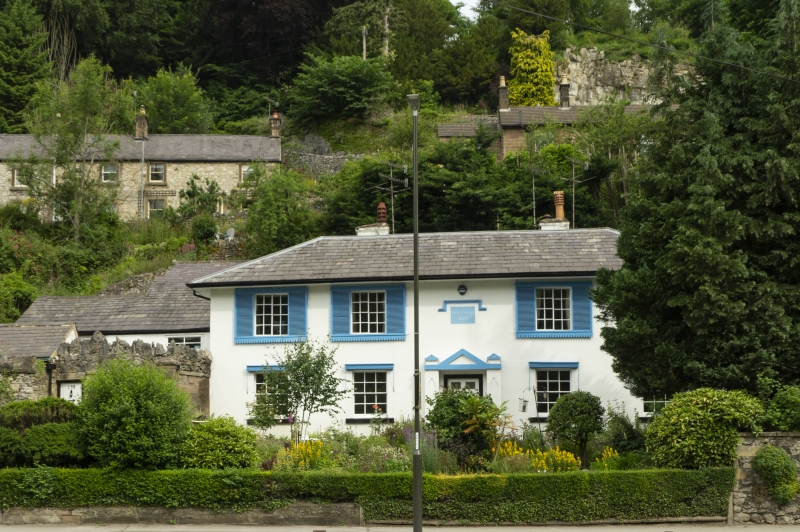
1. DALE ROAD
1390 MATLOCK BATH
No 138
(Dale Cottage)
SK 2959 4/40 22.6.50.
II*
2.
Dated 1820. Stucco; 2 storeys; 4 sash windows with shutters; doorway with
later plain gabled surround, formerly with iron trellis-work porch; central
moulded panel engraved with above date; bold lined eaves; low-pitched slate
roof. An attractive Regency villa.
Listing NGR: SK2955659464
External links are from the relevant listing authority and, where applicable, Wikidata. Wikidata IDs may be related buildings as well as this specific building. If you want to add or update a link, you will need to do so by editing the Wikidata entry.


Other nearby listed buildings
