Approximate Location Map
Large Map »
Latitude: 51.0717 / 51°4'17"N
Longitude: -1.7965 / 1°47'47"W
OS Eastings: 414350
OS Northings: 130279
OS Grid: SU143302
Mapcode National: GBR 517.NMK
Mapcode Global: FRA 7639.5WX
Plus Code: 9C3W36C3+M9
Entry Name: Ivy Place
Listing Date: 12 October 1972
Grade: II
Source: Historic England
Source ID: 1249015
English Heritage Legacy ID: 318907
ID on this website: 101249015
Location: Salisbury, Wiltshire, SP1
County: Wiltshire
Civil Parish: Salisbury
Built-Up Area: Salisbury
Traditional County: Wiltshire
Lieutenancy Area (Ceremonial County): Wiltshire
Church of England Parish: Salisbury St Thomas and St Edmund
Church of England Diocese: Salisbury
Tagged with: Building Terrace of houses
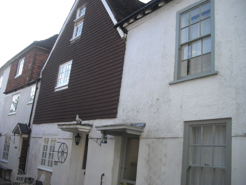
CASTLE STREET
1.
1594 (West Side)
Ivy Place
[Nos 1 to 3 (consec)]
SU 1430 SW 1/405
II GV
2.
C17 altered. Perhaps formerly one house. 2 storeys and attics. No 2 has
gable to front with new tile hanging to upper part. No 3 has circa 1800
2nd floor with renewed tile hanging. Fronts otherwise roughcast, No 1 has
2 flat roofed dormers. Partly old tiled roofs, hipped to No 3. One window
each. Flush framed sashes glazing bars intact to No 1. Similar sash ground
floor of No 2 with iron framed casements to lst floor and attic. 2 light
casements to No 3. Panelled doors with pedimented hoods. Nos 2 and 3 have
gables to rear nopth fronts and between a tall ledged brick stack.
Interior: some C18 corner fireplaces, reset C17 panelss in ddado.
Nos 1 to 11 (consec) Ivy Place form a group.
Listing NGR: SU1435030279
External links are from the relevant listing authority and, where applicable, Wikidata. Wikidata IDs may be related buildings as well as this specific building. If you want to add or update a link, you will need to do so by editing the Wikidata entry.


Other nearby listed buildings
