Approximate Location Map
Large Map »
Latitude: 51.2383 / 51°14'18"N
Longitude: 0.5212 / 0°31'16"E
OS Eastings: 576095
OS Northings: 151816
OS Grid: TQ760518
Mapcode National: GBR PRM.6M7
Mapcode Global: VHJML.Z4FJ
Plus Code: 9F326GQC+8F
Entry Name: Salts Place
Listing Date: 25 July 1952
Last Amended: 26 February 1987
Grade: II
Source: Historic England
Source ID: 1250632
English Heritage Legacy ID: 433075
ID on this website: 101250632
Location: Loose, Maidstone, Kent, ME15
County: Kent
District: Maidstone
Civil Parish: Loose
Built-Up Area: Maidstone
Traditional County: Kent
Lieutenancy Area (Ceremonial County): Kent
Tagged with: Building
SALTS LANE
TQ 75 SE LOOSE
(West Side)
3/205 Salts Place (formerly listed
25.7.52 as Salts Farmhouse)
GV II
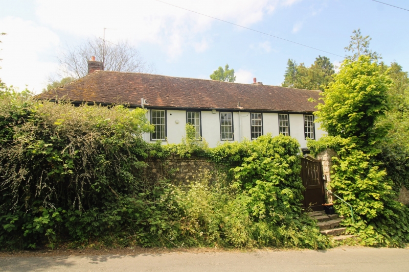
Farmhouse, now house pair. C16 or earlier, with C17 and early C18
alterations and additions and late C18 facade. Timber-framed, clad
with channelled render. Plain tile roof. 2 storeys, garret and
cellar on stone plinth. Eaves cornice of paired Ionic modillions.
Roof hipped to left, hip returning to rear. Brick stack towards front
of rear left return wing, and rear stack to right of centre. Regular
9-window front of 12-pane sashes in open boxes, some with thick glazing
bars. 3-light ovolo-moulded mullion garret window to right. Two
doors, one under fifth and one under eighth window from left end,
each of eight fielded panels, with fluted Doric architrave and flat
hood on paired Ionic modillions. Right door up 2 steps. Rear left
return wing, with 4 first-floor sashes, partly overlapping short rear
wing or turret towards centre of left half of main range. Short
parallel rear range with C17 origins towards left end of right half of
main range, with further addition to right of it. Interior: only
partly inspected. Panelled ground-floor room to left half of main
range. Exposed framing and partitions. C17 stone fireplace with
chamfered jambs. Initials and date DM 1727 pricked in plaster in
first-floor room towards right end.
Listing NGR: TQ7609551816
External links are from the relevant listing authority and, where applicable, Wikidata. Wikidata IDs may be related buildings as well as this specific building. If you want to add or update a link, you will need to do so by editing the Wikidata entry.


Other nearby listed buildings
