Approximate Location Map
Large Map »
Latitude: 51.8934 / 51°53'36"N
Longitude: -1.4928 / 1°29'34"W
OS Eastings: 435000
OS Northings: 221776
OS Grid: SP350217
Mapcode National: GBR 6TF.7DD
Mapcode Global: VHBZH.2NPV
Plus Code: 9C3WVGV4+9V
Entry Name: Almshouses and Attached Front Garden Walls
Listing Date: 27 August 1957
Last Amended: 30 August 1988
Grade: II
Source: Historic England
Source ID: 1251415
English Heritage Legacy ID: 434105
ID on this website: 101251415
Location: Spelsbury, West Oxfordshire, OX7
County: Oxfordshire
District: West Oxfordshire
Civil Parish: Spelsbury
Traditional County: Oxfordshire
Lieutenancy Area (Ceremonial County): Oxfordshire
Church of England Parish: Spelsbury
Church of England Diocese: Oxford
Tagged with: Almshouse
SPELSBURY B4026
SP3421-3521, SP3421-3521 (West side)
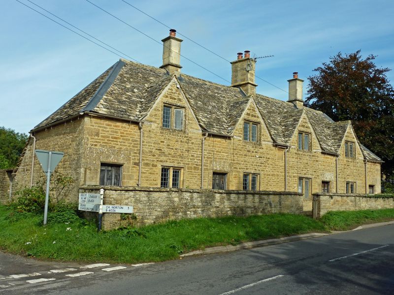
16/154, 17/154 Nos.1, 2, 3 and 4 Almshouses
27/08/57 and attached front garden
walls
(Formerly listed as
Almshouses)
II
Row of 4 almshouses and garden wall. 1688 for John Cary, extended C20. Coursed
squared limestone with ashlar dressings; Stonesfield-slate roof with ashlar
ridge stacks. Single-unit rear outshut plans with small rear-extensions. One
storey plus attic. Symmetrical 4-gabled front has leaded 2-light stone-mullioned
windows at both floors, and each cottage has a chamfered stone doorway with a
ribbed oak door. Hipped roof has 3 stacks with plinths and moulded caps. Central
moulded datestone, below a straight label, is inscribed "Cary/II/1688", A re-set
stone sundial to extreme left has a scrolled hood with a cherub face and is
probably C17. Rear of row has a catslide roof and 2 single-storey stone-tiled
extensions. Interior: stop-chamfered spine beams; butt-purlin roof. Front garden
wall, approx. 1.2m high, extends from both ends of the row and encloses a narrow
area with a central gateway. The sundial is said to have come from the village
poor-house.
(Buildings of England: Oxfordshire: p775)
Listing NGR: SP3500021776
External links are from the relevant listing authority and, where applicable, Wikidata. Wikidata IDs may be related buildings as well as this specific building. If you want to add or update a link, you will need to do so by editing the Wikidata entry.


Other nearby listed buildings
