Approximate Location Map
Large Map »
Latitude: 53.8725 / 53°52'21"N
Longitude: -1.7511 / 1°45'3"W
OS Eastings: 416464
OS Northings: 441843
OS Grid: SE164418
Mapcode National: GBR JR6N.PK
Mapcode Global: WHC8X.2XFM
Plus Code: 9C5WV6FX+2H
Entry Name: Hawkslyn
Listing Date: 7 April 1988
Grade: II
Source: Historic England
Source ID: 1252587
English Heritage Legacy ID: 433668
ID on this website: 101252587
Location: Hawksworth, Leeds, West Yorkshire, LS20
County: Leeds
Electoral Ward/Division: Guiseley and Rawdon
Parish: Non Civil Parish
Built-Up Area: Hawksworth
Traditional County: Yorkshire
Lieutenancy Area (Ceremonial County): West Yorkshire
Church of England Parish: Guiseley St Oswald King and Martyr
Church of England Diocese: Leeds
Tagged with: Building
AIREBOROUGH MAIN STREET
SE 14 SE
LS 20 (north side)
Hawksworth
4/58 Hawkslyn
-
GV II
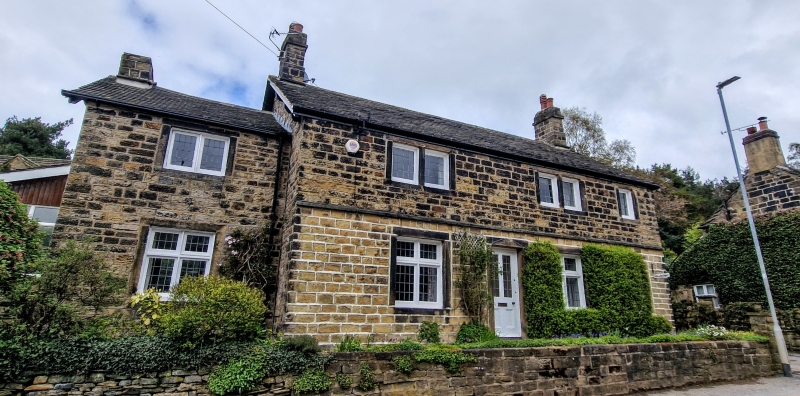
Farmhouse, now house. Late C17, remodelled in C18, altered. Coursed squared
sandstone, roof of stone-coloured composition tiles. Two-unit plan with
continuous rear outshut under catslide roof, added wing set back at left end.
Two storeys. Main range; three 1st floor windows; lst-floor dripmould;
doorway offset to left of centre has plain lintel, windows have similar
surrounds and mullions: at ground floor a large window each side of the door,
perhaps formerly with mullions but now cross-window casements, and at right
hand end a single-light window; at 1st floor two 2-light windows and a
similar single light at right hand end. Single-bay wing to left has similar
windows. Chimneys on principal gables and gable of wing. Right hand return
wall has inter alia a former doorway altered as a window, and a very tall
doorway to the outshut (said to be entrance for horse); rear of less
interest, but has chimney on slope of roof at junction with outshut.
Interior: two C17 chamfered beams in left room, a similar beam in right-hand
room with scarf joint suggesting former firehood bressumer; large king-post
roof truss with V-struts, and many large taper-marks in the tie-beam; in
outshut the lower part of a flight of stone steps which were formerly
external access to rear upper room.
History: said to have been coaching inn, the stables having been on the
opposite side of the road.
Listing NGR: SE1646441843
External links are from the relevant listing authority and, where applicable, Wikidata. Wikidata IDs may be related buildings as well as this specific building. If you want to add or update a link, you will need to do so by editing the Wikidata entry.


Other nearby listed buildings
