Approximate Location Map
Large Map »
Latitude: 53.438 / 53°26'16"N
Longitude: -2.267 / 2°16'1"W
OS Eastings: 382362
OS Northings: 393503
OS Grid: SJ823935
Mapcode National: GBR DCZ.VK
Mapcode Global: WHB9N.4VR7
Plus Code: 9C5VCPQM+66
Entry Name: Rowthorne House
Listing Date: 31 October 1989
Grade: II
Source: Historic England
Source ID: 1254629
English Heritage Legacy ID: 457623
ID on this website: 101254629
Location: Chorlton-cum-hardy, Manchester, Greater Manchester, M21
County: Manchester
Electoral Ward/Division: Chorlton Park
Parish: Non Civil Parish
Built-Up Area: Manchester
Traditional County: Lancashire
Lieutenancy Area (Ceremonial County): Greater Manchester
Church of England Parish: Chorlton-cum-Hardy St Werburgh
Church of England Diocese: Manchester
Tagged with: House
MANCHESTER
SJ89SW ST WERBURGH'S ROAD
698-1/8/587 (West side)
31/10/89 Chorlton-Cum-Hardy
Rowthorne House
GV II
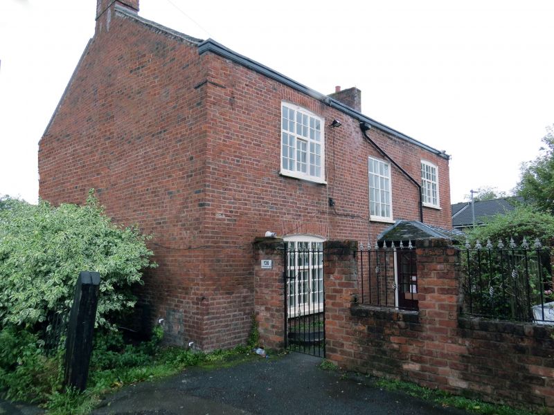
Farmhouse,now office. Later C18, altered. Red brick in Flemish
bond (sides and rear in English garden wall bond), composition
tile roof. Rectangular double-depth plan. Two storeys, a
symmetrical 3-window facade; central round-headed doorway (now
blocked) with imposts, under shallow C20 porch imitating
open-pedimented C18 doorcase; altered windows with small-pane
glazing, those at ground floor enlarged and furnished with C20
bows and those above with C20 tilting casements, all these
windows with flat-arched heads of gauged brick. Dentilled
wooden eaves cornice; gable chimneys. C20 single-storey
addition at left end. The rear, facing the barn (q.v.), has a
C20 porch to the back door but is otherwise almost completely
original, all the windows having wooden mullions and transoms:
2 large segmental-headed 6-light windows on each floor, all
with small panes and mostly with a horizontal-sliding sash
opening in the centre of the lower tier (but that to the right
at ground floor with restored joinery in matching style except
the opening, which is a top-hung casement). Below the other
ground floor window are 2 semicircular steps (the upper of
wood), probably a former milk-churn stand. Interior altered.
Forms group with the barn approx. 10 metres north.
Listing NGR: SJ8236293503
External links are from the relevant listing authority and, where applicable, Wikidata. Wikidata IDs may be related buildings as well as this specific building. If you want to add or update a link, you will need to do so by editing the Wikidata entry.


Other nearby listed buildings
