Approximate Location Map
Large Map »
Latitude: 52.9479 / 52°56'52"N
Longitude: -1.1389 / 1°8'20"W
OS Eastings: 457954
OS Northings: 339293
OS Grid: SK579392
Mapcode National: GBR LRR.KD
Mapcode Global: WHDGZ.G5WD
Plus Code: 9C4WWVX6+5C
Entry Name: London Road Railway Station and Adjoining Goods Sheds and Canopies
Listing Date: 12 July 1972
Last Amended: 30 November 1995
Grade: II
Source: Historic England
Source ID: 1254699
English Heritage Legacy ID: 457443
ID on this website: 101254699
Location: Castle College, Lace Market, Nottingham, Nottinghamshire, NG2
County: City of Nottingham
Electoral Ward/Division: Bridge
Parish: Non Civil Parish
Built-Up Area: Nottingham
Traditional County: Nottinghamshire
Lieutenancy Area (Ceremonial County): Nottinghamshire
Church of England Parish: Nottingham St Saviour
Church of England Diocese: Southwell and Nottingham
Tagged with: Railway station Former railway station
NOTTINGHAM
SK5739SE LONDON ROAD
646-1/24/329 (East side)
12/07/72 London Road Railway Station and
adjoining goods sheds and canopies
(Formerly Listed as:
LONDON ROAD
London Road Railway Station (low
level))
GV II
Also known as: Low Level Station GREAT NORTHERN CLOSE.
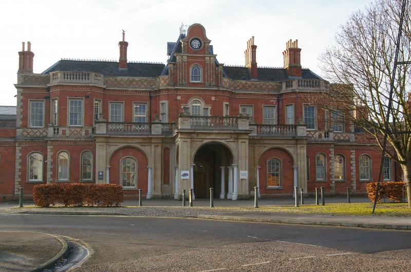
Railway station, now disused. 1857. By TC Hine of Nottingham
for the Great Northern Railway Co. Goods sheds and additions
c1900. Restored c1987 and 1993. Red brick, with ashlar and
yellow brick dressings and gabled and hipped slate roofs with
tile cresting. 9 original coped brick ridge stacks, 2 similar
side wall stacks. Anglo-Italian style.
EXTERIOR: the main range and entrance face north, with a
secondary range to the right, facing west. The ranges are
linked by a single storey rounded corner. At the south end, a
late C19 addition. On the south side, extensive goods sheds,
and platform canopies with valanced roofs.
Main range, 2 storeys plus attics; 7 bays. Plinth, quoins,
first floor cornice, diaper work parapet. Windows are mainly
glazing bar sashes, with round-arched dummy windows to the
ground floor. Central round-arched porte-cochere with panelled
pilasters, cast-iron columns, and balustrade. Behind this, a
single storey range, 3 bays, with similar pilasters and
balustrade. Blank round arches containing dummy windows to
front and each end.
Main block has a projecting central bay with rounded corners
and a Venetian window flanked by side windows. Above, a shaped
gable with polychrome pilasters, containing a round-arched
window and clock. Behind the gable, a truncated pyramidal roof
with cast-iron crest. Side bays have 2 windows. Beyond,
projecting bays with 2 ground floor windows and canted upper
floors with 3 windows and balustrades. End bays have a single
window on each floor. Single storey range to left, 3 windows.
Rounded corner, to right, has a central external stack,
flanked on each side by 2 windows and a door.
West front, single storey plus attics; 9 window range. First
floor cornice and single coped gable. Off-centre entrance bay
with pediment containing a Venetian window. Irregular
fenestration to ground floor. Attics have 8 round-arched
through-eaves dormers.
At the south end, late C19 addition, 2 storeys; 4 window
range. Cart entrance with steel lintel. Adjoining the west
side, an open shed, 3 bays, with cast-iron columns and
valanced wooden roof.
On the south and east sides, goods sheds, 3 bays wide, with
valanced platform canopies. Steel and cast-iron structure with
wooden cladding and slate roofs with clerestory and glazed
ventilators.
The station was disused from 1900, and was used as a parcels
depot from 1944-c1985.
(The Buildings of England: Pevsner N: Nottinghamshire: London:
1979-: 247; Get to know Nottingham: Brand K: Thomas Chambers
Hine ; an architect of Victorian Nottingham: Nottingham: 19;
Palmer M & Neaverson P: Industrial Landscapes of the East
Midlands: Chichester: 1992-: 141).
Listing NGR: SK5795439293
External links are from the relevant listing authority and, where applicable, Wikidata. Wikidata IDs may be related buildings as well as this specific building. If you want to add or update a link, you will need to do so by editing the Wikidata entry.


Other nearby listed buildings
