Approximate Location Map
Large Map »
Latitude: 52.2275 / 52°13'38"N
Longitude: -2.7385 / 2°44'18"W
OS Eastings: 349657
OS Northings: 259066
OS Grid: SO496590
Mapcode National: GBR FK.1TJY
Mapcode Global: VH84W.H84R
Plus Code: 9C4V67G6+XJ
Entry Name: 12 and 14 Drapers Lane
Listing Date: 9 July 1976
Last Amended: 3 October 2023
Grade: II
Source: Historic England
Source ID: 1255428
English Heritage Legacy ID: 459679
ID on this website: 101255428
Location: Leominster, County of Herefordshire, HR6
County: County of Herefordshire
Civil Parish: Leominster
Built-Up Area: Leominster
Traditional County: Herefordshire
Lieutenancy Area (Ceremonial County): Herefordshire
Church of England Parish: Leominster
Church of England Diocese: Hereford
Tagged with: Building
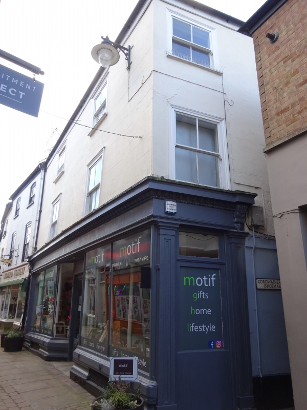
House and shop constructed during the early to mid-C18, altered during the late-C19 with a new shopfront and windows.
House and shop constructed during the early to mid-C18, altered during the late-C19 with a new shopfront and windows.
MATERIALS: the building is rendered externally, with a timber and glass shopfront on the ground floor onto Drapers Lane. The roof covering is understood to be composite tile.
PLAN: the building occupies an almost square plan with a principal frontage onto Drapers Lane to the east and a flank elevation fronting Cordwainers Lane to the north.
EXTERIOR: the building is three storeys in height plus cellar, across two wide bays onto both Drapers Lane and Cordwainers Lane, under a hipped roof. The principal, east elevation is symmetrically arranged with a good quality late-C19 shopfront with Classical motifs and a canted central entrance with a panelled, half-glazed door. Either side of the entrance is a moulded stone plinth and low, moulded timber stallrisers which are intersected by cast iron cellar grilles, with slender mullions framing large, plate-glass shop windows. Above the shop windows is a fascia board with egg and dart mouldings to the cornice and architrave, terminated by elaborate console brackets rising from panelled pilasters which frame the shopfront. The shopfront returns a short way onto the north elevation.
The first and second floors each contain a pair of late-C19 horned sash windows with two-over-two glazing, set within moulded timber surrounds which sit proud of the stuccoed façade. Above the second-floor windows is a modern fascia board and guttering.
Within the easternmost section of the north elevation fronting Cordwainers Lane, there is a two-over-two glazed, timber sash window with horns and a moulded timber surround on the first and second floors over the shopfront return. Further to the west on the ground floor, there is a C19 plank door, a C20, four-panelled door with barred overlight and a shop window blocked with timber planks, all unified by a timber fascia board. Above this arrangement, there is a large, timber sash window with ten-over-ten glazing, set within a moulded timber surround on the first floor, and a two-over-two sash window, possibly uPVC, on the second floor.
The town of Leominster traces its origins to the establishment of a religious house there during the C7 or earlier. The Saxon settlement endured repeated Viking raids and is recorded as a sizeable town in the Domesday Book (1086), with 27 households. In the early-C12, King Henry I established a Benedictine Priory in the town and granted a foundation charter for the town’s market. The town thrived throughout the later medieval period, despite periodic unrest due to its location in the border region. Leominster wool was prized across Europe and bestowed considerable wealth upon the town. The town centre retains many medieval and early-modern buildings; secular buildings are timber framed while surviving Priory buildings are constructed of local sandstone. The town centre retains an essentially medieval street pattern, with long, narrow burgage plots fronting the north-south spine road of Broad Street-High Street-South Street, and Corn Square (the historic market place) lying to the east of the High Street. The remains of the Priory, dissolved in 1539, lie to the north-east of the town centre. The town remained a prominent local centre into the C18 and C19. During this period, many timber-framed buildings were replaced (or refronted) by brick buildings with Classical elevations. Many houses in the town centre were partially converted to commercial use and equipped with shopfronts during the later-C19 and C20.
12 and 14 Drapers Lane were constructed during the early to mid-C18, probably on the site of an earlier building. Possibly built as a house with commercial premises beneath, the current shopfront was installed during the late-C19, which may have coincided with the installation of the horned sash windows on the first and second floors. The building is currently (2022) in use as a shop with a dwelling above.
External links are from the relevant listing authority and, where applicable, Wikidata. Wikidata IDs may be related buildings as well as this specific building. If you want to add or update a link, you will need to do so by editing the Wikidata entry.


Other nearby listed buildings
