Latitude: 53.7968 / 53°47'48"N
Longitude: -1.541 / 1°32'27"W
OS Eastings: 430332
OS Northings: 433481
OS Grid: SE303334
Mapcode National: GBR BKL.KR
Mapcode Global: WHC9D.9TFQ
Plus Code: 9C5WQFW5+PJ
Entry Name: 14-34, CENTRAL ROAD (See details for further address information)
Listing Date: 11 September 1996
Grade: II
Source: Historic England
Source ID: 1255653
English Heritage Legacy ID: 465782
ID on this website: 101255653
Location: Steander, Leeds, West Yorkshire, LS1
County: Leeds
Electoral Ward/Division: City and Hunslet
Parish: Non Civil Parish
Built-Up Area: Leeds
Traditional County: Yorkshire
Lieutenancy Area (Ceremonial County): West Yorkshire
Church of England Parish: Leeds City
Church of England Diocese: Leeds
Tagged with: Building
LEEDS
SE3033SW CENTRAL ROAD 714-1/78/90 (East side) Nos.14-34 (Consecutive)
II
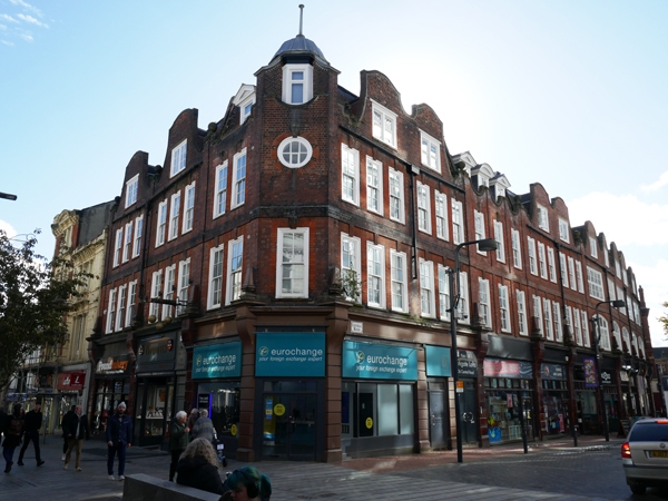
Includes: Nos.119, 120 AND 121 KIRKGATE. Shops, workshops and offices. c1900. Red brick, tile roof. 3 storeys with attic gables and dormers, 12 bays to Central Road, 3 to Kirkgate (left return, Nos 119-121) and 3 with access to rear on right return (Central Road). In Queen Anne Revival style. Ground floor: original shop facade with giant tile-faced pilasters and brackets surmounted by obelisks between 1st-floor windows, sign boards replaced. 1st floor: west side has five 3-window bays, 6 multi-pane segmental-arched windows, one 3-window bay; 2nd floor similar. Attic storey: small-paned gable windows and pedimented dormers. Shop divisions carried up as brick pilasters to ramped parapet and ball finial; brick band at 2nd-floor level. Left return: 3-, 3- and 2-window bays, 2 gables left and dormer window with triangular pediment right. Right return: eight 1st-floor windows, round-arched access to rear has fine wrought-iron gates. INTERIOR: not inspected. The block was built by 1910 on part of the area occupied by the 1824 Central Market (corner Duncan Street and New Market Street) which was cleared after 1886. (Ordnance Survey Map of Leeds: 1910-; Insurance Map of Leeds: 1886-).
Listing NGR: SE3033233481
External links are from the relevant listing authority and, where applicable, Wikidata. Wikidata IDs may be related buildings as well as this specific building. If you want to add or update a link, you will need to do so by editing the Wikidata entry.


Other nearby listed buildings