Approximate Location Map
Large Map »
Latitude: 53.7968 / 53°47'48"N
Longitude: -1.5421 / 1°32'31"W
OS Eastings: 430260
OS Northings: 433484
OS Grid: SE302334
Mapcode National: GBR BKL.9R
Mapcode Global: WHC9D.8TXP
Plus Code: 9C5WQFW5+P5
Entry Name: 133, 135 and 137, Briggate
Listing Date: 7 May 1992
Grade: II
Source: Historic England
Source ID: 1255830
English Heritage Legacy ID: 465588
ID on this website: 101255830
Location: Steander, Leeds, West Yorkshire, LS1
County: Leeds
Electoral Ward/Division: City and Hunslet
Parish: Non Civil Parish
Built-Up Area: Leeds
Traditional County: Yorkshire
Lieutenancy Area (Ceremonial County): West Yorkshire
Church of England Parish: Leeds City
Church of England Diocese: Leeds
Tagged with: Building
LEEDS
SE3033SW BRIGGATE
714-1/78/65 (East side)
07/05/92 Nos.133, 135 AND 137
GV II
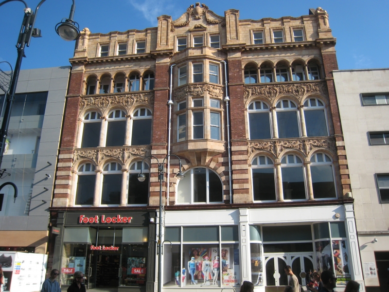
Post Office exchange, now shop premises. 1907. By Percy
Robinson; top storey added c1920, altered C20. Red brick and
pink terracotta, tiled facade to top storey, roof not visible.
5 storeys, 3 bays. In Renaissance style.
Ground floor facade possibly preserved behind later C20 shop
fronts; the central bay narrower and with a round-headed
window of 3 lights to first floor, canted bay windows to 2nd
and 3rd floors; the flanking bays, 1st and 2nd floors, have 3
round-arched windows slightly recessed behind an ornate facade
of tall columns supporting a deep spandrel band with relief
moulded decoration of figures, swags and foliage; the
3rd-floor windows deeply recessed behind a 5-arched facade;
entablature, modillion cornice. Pilasters flank central bay
and corners; terracotta used as banded rustication to 1st
floor. 4th floor: 3 rectangular windows to each bay, pilasters
with moulded panels, ball finials to corners, central plaque
and swags to gablet; gable screen walls.
INTERIOR: not inspected.
Exchange Buildings was an adaptation of the original scheme of
shops at a cost of »6,000. The principal floor of approx 3,000
square yards comprised the post and telegraph office,
telephone boxes, letter boxes and lockers; grocery exchange to
1st floor with a reading room and writing room; the 2 upper
floors were offices; basement cafe. By 1920 the building was
used by FW Woolworth & Co. Percy Robinson also designed Nos 4
(qv), 6 & 8 (not included) Duncan Street and Armley Public
Library, Stocks Hill (qv).
(Kelly's Directory: 1908-: XXXI).
Listing NGR: SE3026033484
External links are from the relevant listing authority and, where applicable, Wikidata. Wikidata IDs may be related buildings as well as this specific building. If you want to add or update a link, you will need to do so by editing the Wikidata entry.


Other nearby listed buildings
