Approximate Location Map
Large Map »
Latitude: 53.8149 / 53°48'53"N
Longitude: -1.609 / 1°36'32"W
OS Eastings: 425840
OS Northings: 435475
OS Grid: SE258354
Mapcode National: GBR B3D.17
Mapcode Global: WHC9C.8C1R
Plus Code: 9C5WR97R+X9
Entry Name: Kirkstall Brewery Student Village
Listing Date: 9 March 1987
Last Amended: 11 September 1996
Grade: II
Source: Historic England
Source ID: 1255819
English Heritage Legacy ID: 465624
ID on this website: 101255819
Location: Sandford, Leeds, West Yorkshire, LS5
County: Leeds
Electoral Ward/Division: Kirkstall
Parish: Non Civil Parish
Built-Up Area: Leeds
Traditional County: Yorkshire
Lieutenancy Area (Ceremonial County): West Yorkshire
Church of England Parish: Bramley St Peter
Church of England Diocese: Leeds
Tagged with: Brewery Student housing
LEEDS
SE2535 BROAD LANE, Kirkstall
714-1/21/898 (North side)
09/03/87 Kirkstall Brewery Student Village
(Formerly Listed as:
BROAD LANE, Kirkstall
Kirkstall Brewery)
GV II
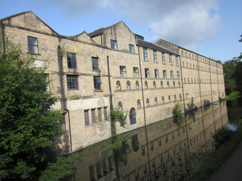
Maltings, then brewery, now student accommodation. Late C18
and early C19 for Joseph Musgrove; alterations and additions
1833-47 for Thomas Walker, 1847-69 for Benjamin Dawson and
Company, 1869-1954 for the Kirkstall Brewing Company, and
1954-83 for Whitbread and Co. Conversion 1994 to student
village for Leeds Metropolitan University.
Coursed squared gritstone, some with herring-bone tooling, C20
brickwork; slate roofs with some corrugated iron, felting and
metal sheeting.
L-shaped plan: tower brewery, yard entrance and office range
facing Broad Lane (S); brewery workshop and warehouse ranges
parallel to the Leeds and Liverpool Canal (E). C20 additions
in angle.
Broad Lane facade: 3-storey, 3 x 2-bay tower brewery left,
chamfered plinth, each bay treated as a giant segmental-arched
recess having paired windows with segmental-arched lintels,
some blind, round-arched cart entrance on left return, moulded
string, ashlar cornice, balustraded parapet. A circular
tapering chimney rises from the SW corner of the tower and the
corner bays below it project slightly and have blind windows;
hipped roof of green slates with skylights and ridge louvres.
The lower half of the tower is obscured by a stone range on
roadside, raised to 2 storeys C20 and rendered; on left
return, to rear, a gabled bay with round-arched loading door
left, square windows, central loading doors to 1st and 2nd
floors.
Broad Lane frontage, from left to right: a single-storey bay
with square window in plain surround, louvred ridge; 3-window
gabled bay with blocked 2-light and square windows (boarded
up) and keyed oculus in coped gable; ashlar entrance bay with
raised lintel, modillion cornice, blocking course, hipped
roof; far right a 3-bay office range, 2 storeys to road, 3 to
canal: rusticated ashlar quoins, plinth and sill bands, late
C19 ashlar porch with double doors and fanlight, cusped side
lights, modillion cornice, raised stone surrounds to paired
tall windows left, smaller to right and 1st floor centre and
right, sash frames replaced with C20 casements; ashlar gable
coping right, corniced end stacks.
A low stone wall supporting iron railings with spiked bars and
scalloped top rail running from porch to entrance bay left,
and to canal bridge (qv) right.
Right return (facade to canal), from left: gable end of office
range with 2 first-floor windows; twin-gabled late C18-early
C19 3-storey range, 3 bays, with altered and blocked
flat-faced mullion windows to lower floor, upper windows with
plain stone surrounds and raised sills, most inserted, bands
at 1st floor, 1st-floor lintel, and eaves levels, ashlar coped
gables.
4-storey, 9-bay range with plinth to lower 2 floors, small
round-arched windows and blocked doorway left, flat-headed,
stone-lintelled windows above, and next floor raised at
different times over right-hand part (taller windows set under
eaves with grouped gutter brackets between) and 3 left bays
(under gable with attic window and ashlar coping) which are
separated by a straight joint.
4-storey, 20-bay range with small round-arched windows on sill
bands, blocked round-arched ground-floor doorways (on to
canal) at either end; plain gutter brackets, 2-span roof. The
rear yard surface is higher than the canal and the 20-bay
range has 2 tiers of round-arched windows, sill band, the wide
loading doors at ground level breaking the sill band of the
lower windows.
To right the 2-storey, 4-window range has blocked round-arched
openings low down and brick upper storey; to right again a
wide and a narrow round-arched opening, and stone steps down
to cellars below yard level.
INTERIOR: gutted of plant since 1983 closure of the brewery,
although original structural supports survive: squat, circular
cast-iron columns supporting riveted cast-iron girders in
1st-floor (from canal side). The 4-bay range originally had a
further lower storey exposed on the yard (west) side but this
was blocked off when the yard level was raised, forming the
cellar. In 1994 this was excavated to reveal the original
lower storey.
HISTORICAL NOTE: in 1793 Henry Cooper and Joseph Musgrave
leased 2 plots from Sir James Graham. Henry Cooper built
maltings, wharf, Cooper House (qv) for himself and Poplar
House for his maltster; Joseph Musgrave also built maltings,
cottages and Grove House. From 1814-32 the maltings were
operated by Ephraim Elsworth; in 1833 Thomas Walker bought
them and made a brewery, he died a bankrupt in 1844 and Simeon
Musgrave sold out to Benjamin Dawson and Co.
There was considerable building expansion 1847-69, including
the 20-bay range, and in 1872 the Kirkstall Brewery Company
bought the site and the tower brewery was built. By 1898 a
huge international trade had developed using the canal system
and by steamship from Goole. In 1936 the business was taken
over by Duttons of Blackpool; bought by Whitbreads in 1954 and
closed down 1983.
(Brears P: History of Kirkstall Brewery: 1985-; Brears P:
Heritage Trail: 1993-).
Listing NGR: SE2584035475
External links are from the relevant listing authority and, where applicable, Wikidata. Wikidata IDs may be related buildings as well as this specific building. If you want to add or update a link, you will need to do so by editing the Wikidata entry.


Other nearby listed buildings
