Latitude: 53.8167 / 53°48'59"N
Longitude: -1.6101 / 1°36'36"W
OS Eastings: 425766
OS Northings: 435667
OS Grid: SE257356
Mapcode National: GBR B2C.SM
Mapcode Global: WHC9C.7BJF
Plus Code: 9C5WR98Q+MX
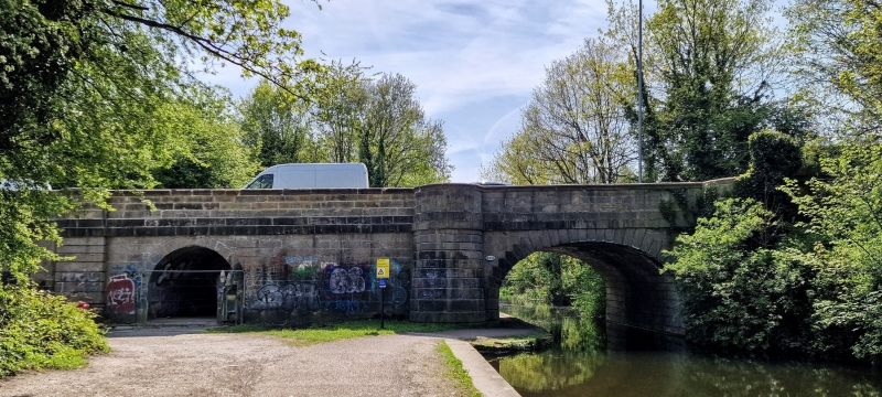
Entry Name: Bridge 221A over Leeds and Liverpool Canal
Listing Date: 5 August 1976
Last Amended: 11 September 1996
Grade: II
Source: Historic England
Source ID: 1375081
English Heritage Legacy ID: 465961
ID on this website: 101375081
Location: Sandford, Leeds, West Yorkshire, LS5
County: Leeds
Electoral Ward/Division: Bramley and Stanningley
Parish: Non Civil Parish
Traditional County: Yorkshire
Lieutenancy Area (Ceremonial County): West Yorkshire
Church of England Parish: Bramley St Peter
Church of England Diocese: Leeds
Tagged with: Bridge
LEEDS
SE2535 LEEDS AND BRADFORD ROAD, Kirkstall 714-1/21/902 Bridge 221A over Leeds and Liverpool 05/08/76 Canal (Formerly Listed as: LEEDS AND LIVERPOOL CANAL Bridge 221A (Sandford))
GV II
Bridge carrying the Leeds and Bradford Turnpike over the Leeds and Liverpool Canal and towpath on E side. 1800. Ashlar, with rusticated voussoirs to elliptical arch flanked by semicircular rusticated buttresses rising to form refuges at roadside, secondary narrow round arch on E side of canal; band at road level, moulded parapet coping extends to circular bollards on ramped roadside. The Leeds and Bradford Turnpike road was designed by Jonathan Teale and this bridge is shown in JMW Turner's painting of 'Kirkstall Lock' (qv) of 1824.
Listing NGR: SE2576635666
External links are from the relevant listing authority and, where applicable, Wikidata. Wikidata IDs may be related buildings as well as this specific building. If you want to add or update a link, you will need to do so by editing the Wikidata entry.


Other nearby listed buildings