Approximate Location Map
Large Map »
Latitude: 53.7954 / 53°47'43"N
Longitude: -1.5463 / 1°32'46"W
OS Eastings: 429984
OS Northings: 433323
OS Grid: SE299333
Mapcode National: GBR BJM.F7
Mapcode Global: WHC9D.6VXS
Plus Code: 9C5WQFW3+4F
Entry Name: Scarbrough Hotel
Listing Date: 11 September 1996
Grade: II
Source: Historic England
Source ID: 1255910
English Heritage Legacy ID: 465489
ID on this website: 101255910
Location: Granary Wharf, Leeds, West Yorkshire, LS1
County: Leeds
Electoral Ward/Division: City and Hunslet
Parish: Non Civil Parish
Built-Up Area: Leeds
Traditional County: Yorkshire
Lieutenancy Area (Ceremonial County): West Yorkshire
Church of England Parish: Leeds City
Church of England Diocese: Leeds
SE2933SE
714-1/77/24
LEEDS
BISHOPGATE STREET
(East side)
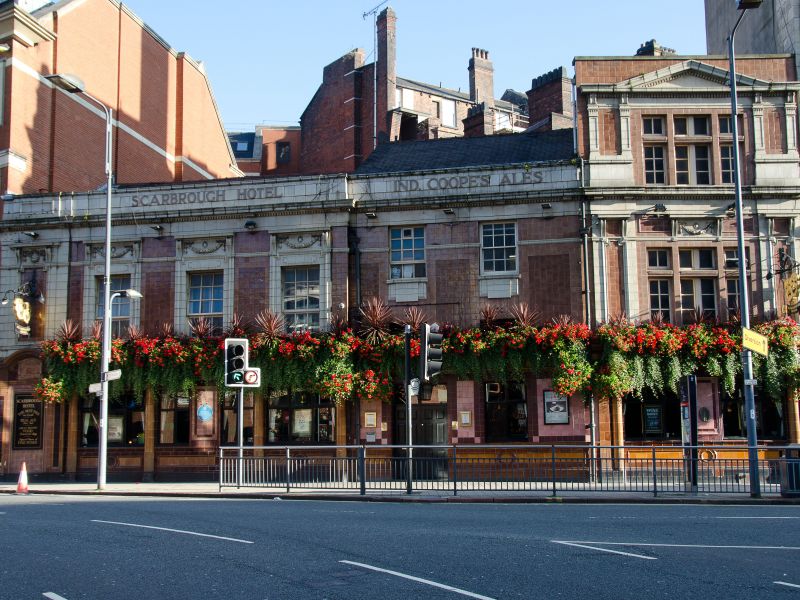
Scarbrough Hotel
II
Public house. Late C18 with earlier remains; early C20
refronting. Brick with terracotta tiles, probably slate roof.
2 storeys, 5 first-floor windows. Decorative details to facade
include attached Ionic columns, contrasting colours to window
surrounds, moulded swags, dentilled cornice and parapet with
name of hotel and brewery in raised letters.
INTERIOR: C20 public house fittings; the rear half of the roof
structure was examined in detail and the front half was
visible. It is extensively altered but shows 3 main phases of
construction: i) at the south-west corner a horizontal beam
set diagonally to the angle of the outer walls is in the
position of a dragon beam in a timber-framed building; it was
not examined closely but appears to have a mortice cut in the
outer end of the upper face. At the same corner a rafter rises
to the ridge and might be part of a hipped roof structure;
much of the timber is reused and brick work visible under the
eaves appears to be C18 or earlier, hand made and irregular in
size.
ii) 2 trusses comprising pairs of tall queen posts clasping a
high collar; pegged joints; lath and plaster and whitewashing
to timbers in the front half of the roof and at gable ends
indicates that the roof space was divided into rooms lit by
gable windows.
iii) A spine wall constructed forward of the ridge; cross
beams cut, the rear portions lifted and built into the raised
back wall of the building; ironwork used in the alterations.
HISTORICAL NOTE: the building stands on the site of the manor
house of medieval Leeds, the brick hall illustrated in
Cossin's map of 1725 having been extensively rebuilt by
Richard Wilson in 1761-5. By the early C19 the building was a
hotel established by Henry Scarborough, the upper part of the
house being altered again at that time, but the building
remembered as formerly the residence of the Wilson family. The
surviving roof structure appears to correspond to the
alterations: phase 1 being the remains of the manor house
structure built by the Wilsons; phase 2, the tall queen posts
and lining to walls, being the work of Henry Scarborough; and
phase 3 the early C20 refurbishing when the frontage was
encased.
(Beresford M: East End, West End; Leeds 1684-1842: Leeds:
1989-: 128-130; Cossins: Map of Leeds: 1725-).
Listing NGR: SE2998433323
External links are from the relevant listing authority and, where applicable, Wikidata. Wikidata IDs may be related buildings as well as this specific building. If you want to add or update a link, you will need to do so by editing the Wikidata entry.


Other nearby listed buildings
