Latitude: 53.7952 / 53°47'42"N
Longitude: -1.5453 / 1°32'43"W
OS Eastings: 430048
OS Northings: 433310
OS Grid: SE300333
Mapcode National: GBR BJM.M9
Mapcode Global: WHC9D.7VDW
Plus Code: 9C5WQFW3+3V
Entry Name: 9 and 10, Mill Hill
Listing Date: 5 August 1976
Grade: II
Source: Historic England
Source ID: 1375191
English Heritage Legacy ID: 466073
ID on this website: 101375191
Location: Granary Wharf, Leeds, West Yorkshire, LS1
County: Leeds
Electoral Ward/Division: City and Hunslet
Parish: Non Civil Parish
Built-Up Area: Leeds
Traditional County: Yorkshire
Lieutenancy Area (Ceremonial County): West Yorkshire
Church of England Parish: Leeds City
Church of England Diocese: Leeds
Tagged with: Building
LEEDS
SE3033SW MILL HILL 714-1/78/256 (East side) 05/08/76 Nos.9 AND 10
GV II
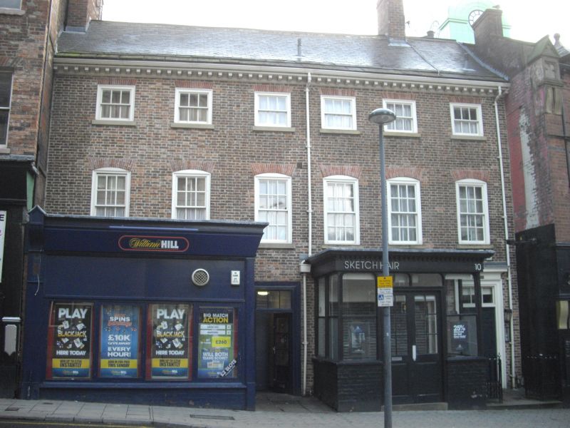
House, warehouse and workshops, now shop and offices. Early C18 with C19 and 20 alterations. Brick, rendered and lined in imitation of ashlar; slate roof, larger eaves courses. Brick stacks: far left (very tall) and to ridge between windows 5 and 6. 3 storeys, 6 windows wide. Tall narrow sashes to first floor, segmental arches, sills, flush frames, traces of wedge lintels. 5 square windows to 2nd floor, sash far left, no window to right, but sill projects. Ground floor: main entrance (No.9) below window 3: moulded surround, overlight; plain entrance (No.10) far right; C20 projecting shop fronts. INTERIOR: main room lit by windows 3, 4, has an C18 fireplace against the left wall: fluted pilasters, dentilled cornice, decorated frieze; fielded-panel shutters to windows. Remains of 2 sets of original stairs: to rear left on upper floors 2 flights, reset, slender column balusters; the right door opens into stairway, the top flight having fine knopped column and vase balusters. Roof structure; at least one truss comprises a king post with braces rising from base to underside of principal rafter. The house built in the first half of the C18, possibly for a merchant clothier and a rare survival in the oldest part of the city. HISTORICAL NOTE: the building was divided up by 1826, probably a horizontal division, No.10 reached from the stairs to right. The premises were then used by a cabinet maker and upholsterer and a boot and shoe maker. By 1839 a tailor and draper was at No.9 and Daniel Backhouse, overlooker (ie in charge of workers in a textile mill) lived at No.10. The tailor and draper remained until at least 1861 but by 1851 an eating house had been established at No.10; maps show that the house then backed onto Princes Court. (Directories of Leeds for 1839, 1851, 1861, 1870: Haigh; White; Ordnance Survey Map of Leeds, surveyed 1847).
Listing NGR: SE3004833310
External links are from the relevant listing authority and, where applicable, Wikidata. Wikidata IDs may be related buildings as well as this specific building. If you want to add or update a link, you will need to do so by editing the Wikidata entry.


Other nearby listed buildings