Approximate Location Map
Large Map »
Latitude: 53.8277 / 53°49'39"N
Longitude: -1.5367 / 1°32'12"W
OS Eastings: 430590
OS Northings: 436926
OS Grid: SE305369
Mapcode National: GBR BL7.GN
Mapcode Global: WHC9D.C1GY
Plus Code: 9C5WRFH7+38
Entry Name: Number 80 and Attached Wall
Listing Date: 11 September 1996
Grade: II
Source: Historic England
Source ID: 1256055
English Heritage Legacy ID: 465314
ID on this website: 101256055
Location: Chapel Allerton, Leeds, West Yorkshire, LS7
County: Leeds
Electoral Ward/Division: Chapel Allerton
Parish: Non Civil Parish
Built-Up Area: Leeds
Traditional County: Yorkshire
Lieutenancy Area (Ceremonial County): West Yorkshire
Church of England Parish: Chapel Allerton St Matthew
Church of England Diocese: Leeds
Tagged with: Building
LEEDS
SE3036 HARROGATE ROAD, Chapel Allerton
714-1/19/566 (East side)
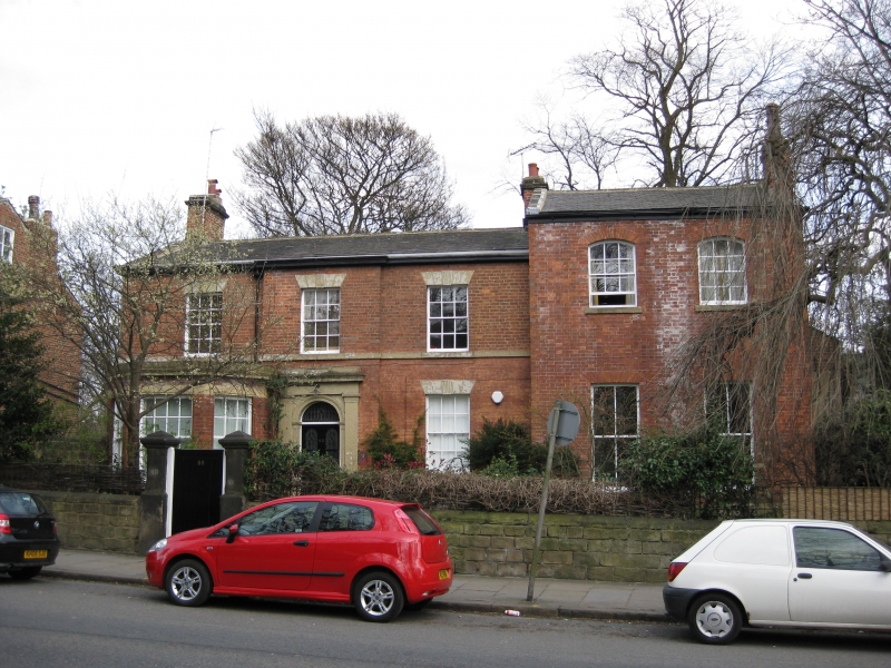
No.80
and attached wall and gate
GV II
House and front garden wall and gate piers. Early C19 with
later C19 addition. Red-brown brick, 5:1 English bond, later
work in Flemish bond, stone details, slate roof.
2-storey, 3-bay main house, central bay projects, glazed
double doors with fanlight in stone surround with pilasters,
entablature, cornice and blocking piece. Sashes with glazing
bars, stone sills and lintels, 1st-floor sill band. Large
canted bay window ground floor left, with 16-pane sash flanked
by sashes with glazing bars. Moulded gutter to eaves, gable
coping left, end brick stacks.
Taller 2-storey, 2-bay addition right has tall 4-pane sashes
to ground floor and segmental-arched sashes with glazing bars
to 1st floor, eaves band, gable copings, stack forward of
ridge, right.
INTERIOR: not inspected.
Stone garden wall to front has rounded coping, is ramped down
twice, with square stone gate piers, moulded pyramidal caps.
Listing NGR: SE3059036926
External links are from the relevant listing authority and, where applicable, Wikidata. Wikidata IDs may be related buildings as well as this specific building. If you want to add or update a link, you will need to do so by editing the Wikidata entry.


Other nearby listed buildings
