Approximate Location Map
Large Map »
Latitude: 53.8505 / 53°51'1"N
Longitude: -1.5666 / 1°33'59"W
OS Eastings: 428607
OS Northings: 439444
OS Grid: SE286394
Mapcode National: GBR KRHX.MG
Mapcode Global: WHC95.XH50
Plus Code: 9C5WVC2M+59
Entry Name: Seven Arches Aqueduct and Conduit Facade
Listing Date: 9 June 1986
Last Amended: 11 September 1996
Grade: II
Source: Historic England
Source ID: 1256089
English Heritage Legacy ID: 465256
ID on this website: 101256089
Location: Black Moor, Leeds, West Yorkshire, LS16
County: Leeds
Electoral Ward/Division: Alwoodley
Parish: Non Civil Parish
Built-Up Area: Leeds
Traditional County: Yorkshire
Lieutenancy Area (Ceremonial County): West Yorkshire
Church of England Parish: Moor Allerton and Shadwell
Church of England Diocese: Leeds
Tagged with: Aqueduct
SE23NE
714-1/6/984
09/06/86
LEEDS
SCOTLAND WOOD, Meanwood Park
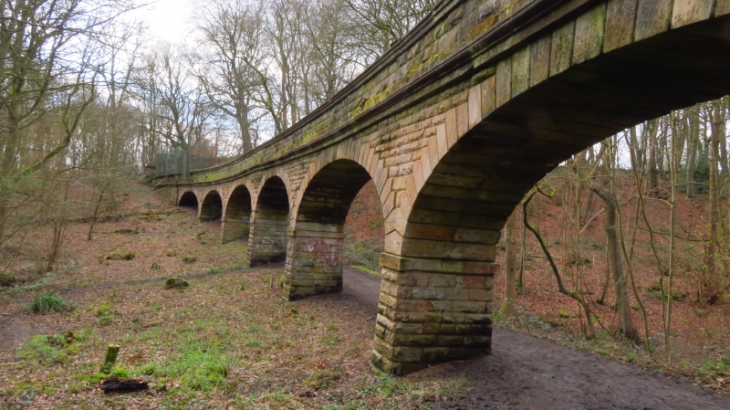
Seven Arches Aqueduct and conduit facade
(Formerly Listed as:
SCOTLAND WOOD, Meanwood Park
Seven Arches Aqueduct and cast-iron culvert)
II
Aqueduct and water conduit over Adel Beck. Aqueduct c1840. By
George Leather, engineer; built by Abraham and Mylne. For the
Leeds Water Works Company. Rock-faced coursed stone and
ashlar.
7 arches supported on attenuated rectangular piers with
stepped voussoirs and decking level moulded string course. 3
courses above to closed conduit. C20 safety railings at each
end. Water conduit: dated 1866; coursed squared gritstone
curbs and revetment walls to stream bed, cast-iron plate
approx 10m downstream from the aqueduct. The plate approx 2.5m
long and 0.75m deep, with mouldings top and bottom and 3
fielded-panels framed by raised mouldings, the centre
enclosing raised lettering: 'LEEDS CORPORATION/ WATER WORKS/
1866'.
Eccup reservoir was built in 1840 to supply clean water (the
first alternative to the River Aire) to the centre of Leeds
after the cholera epidemics of the 1830s. Improvements to the
supplies included the installation of a new mains in 1866,
still in use.
Listing NGR: SE2860739444
External links are from the relevant listing authority and, where applicable, Wikidata. Wikidata IDs may be related buildings as well as this specific building. If you want to add or update a link, you will need to do so by editing the Wikidata entry.


Other nearby listed buildings
