Approximate Location Map
Large Map »
Latitude: 53.7929 / 53°47'34"N
Longitude: -1.5536 / 1°33'12"W
OS Eastings: 429503
OS Northings: 433049
OS Grid: SE295330
Mapcode National: GBR BGN.V4
Mapcode Global: WHC9D.3XGN
Plus Code: 9C5WQCVW+5H
Entry Name: Globe Iron Foundry Fitting Up Shop
Listing Date: 11 September 1996
Grade: II
Source: Historic England
Source ID: 1256244
English Heritage Legacy ID: 465093
ID on this website: 101256244
Location: Camp Field, Leeds, West Yorkshire, LS11
County: Leeds
Electoral Ward/Division: City and Hunslet
Parish: Non Civil Parish
Built-Up Area: Leeds
Traditional County: Yorkshire
Lieutenancy Area (Ceremonial County): West Yorkshire
Church of England Parish: Hunslet St Mary the Virgin
Church of England Diocese: Leeds
Tagged with: Building
LEEDS
SE2933 GLOBE ROAD, Holbeck
714-1/35/842 (North side (off))
No.12
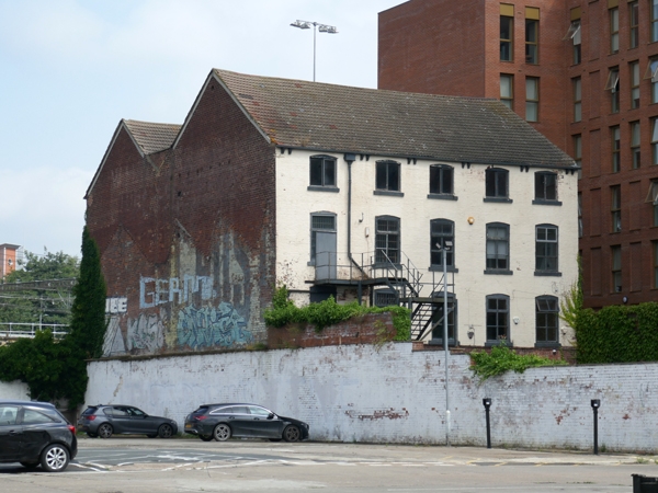
Globe Iron Foundry fitting up shop
GV II
Fitting-up shop, now workshops. c1844, altered C20.
White-painted brick, English bond 1:3 and 1:5, C20 tile roof
of 3 parallel narrow gabled ranges, paired eaves brackets.
4 storeys, 5 first-floor windows to Globe Road frontage:
segmental arches, C20 frames, stone sills, the top storey
windows almost square. Ground floor: 2 wide entrances centre
and left, one blocked, steps up to narrow door with overlight
far right, 5-light window with slender glazing bars to its
left.
Rear, canal facade: blocked door (formerly window) flanked by
narrow windows left; far right: round-arched opening with C20
window frame, one window above and top-floor window blocked.
INTERIOR: not seen in detail: front entrance is into staircase
lobby, a straight flight with bulbous turned balusters rises
to first floor.
The Globe Iron Foundry was established on this site in 1844,
and gave its name to the newly established road; this building
housed the fitting-up shop and probably the engine house as
the openings rear right suggest.
(Victorian Society Walks No.6: Douglas J, Hammond C & Powell
K: Three Suburban Walks: 1987-: 8; Ordnance Survey: Map of
Leeds surveyed 1847: 1850-).
Listing NGR: SE2950333048
External links are from the relevant listing authority and, where applicable, Wikidata. Wikidata IDs may be related buildings as well as this specific building. If you want to add or update a link, you will need to do so by editing the Wikidata entry.


Other nearby listed buildings
