Latitude: 53.9405 / 53°56'25"N
Longitude: -1.1066 / 1°6'23"W
OS Eastings: 458740
OS Northings: 449741
OS Grid: SE587497
Mapcode National: GBR NQQW.66
Mapcode Global: WHDB4.Z760
Plus Code: 9C5WWVRV+58
Entry Name: Cross Keys Hotel
Listing Date: 24 June 1983
Grade: II
Source: Historic England
Source ID: 1256462
English Heritage Legacy ID: 464859
ID on this website: 101256462
Location: Dringhouses, York, North Yorkshire, YO24
County: York
Electoral Ward/Division: Dringhouses & Woodthorpe
Parish: Non Civil Parish
Built-Up Area: York
Traditional County: Yorkshire
Lieutenancy Area (Ceremonial County): North Yorkshire
Church of England Parish: Dringhouses St Edward the Confessor
Church of England Diocese: York
Tagged with: Hotel
YORK
SE5849NE TADCASTER ROAD, Dringhouses 1112-1/26/1213 (West side) 24/06/83 No.32 Cross Keys Hotel
GV II
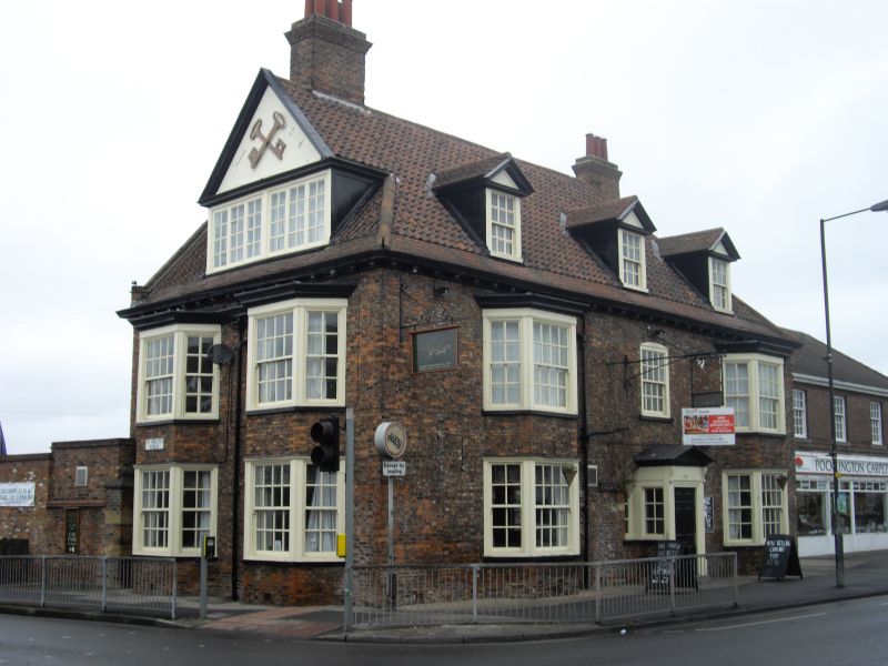
Hotel. Early C18 with alterations in late C18 and 1900. Brick in Flemish bond. Roof pantiled above eaves courses of plain tiles. EXTERIOR: 2 storeys plus attics and 3 bays. The outer bays have 2-storey canted bay windows with glazing bar sashes on brick bases and with flat roofs above cornices. At 1st floor level in the centre there is a blocked window opening with elliptical arch, with a smaller glazing bar sash window within the blocking. The attic dormers are plain tiled and have moulded pedimented gables and glazing bar sashes. In the centre on the ground floor there is a wide carriageway with an elliptical arch, now blocked, but containing narrow windows with glazing bars to each side of an added porch. This porch has a pediment on console brackets, and a door architrave. To the left of the blocked carriageway there is evidence of further rebuilding, including part of a brick band. The left-hand return wall, facing south towards St Helen's Road, has two 2-storey canted bay windows similar to those to the front elevation. The roof above is half-hipped, with a gable above a wide dormer which has casements with glazing bars. INTERIOR: not inspected. RCHM records original staircase with turned balusters with knops, square newels and moulded handrail. An inn has existed on this site since c1250. (RCHME: City of York: South-west of the Ouse: HMSO: 1972-: 117).
Listing NGR: SE5874049741
External links are from the relevant listing authority and, where applicable, Wikidata. Wikidata IDs may be related buildings as well as this specific building. If you want to add or update a link, you will need to do so by editing the Wikidata entry.


Other nearby listed buildings