Approximate Location Map
Large Map »
Latitude: 51.0613 / 51°3'40"N
Longitude: -1.8083 / 1°48'29"W
OS Eastings: 413528
OS Northings: 129129
OS Grid: SU135291
Mapcode National: GBR 51D.KLN
Mapcode Global: FRA 7639.TKF
Plus Code: 9C3W356R+GM
Entry Name: Old School
Listing Date: 12 October 1972
Grade: II
Source: Historic England
Source ID: 1258223
English Heritage Legacy ID: 444605
ID on this website: 101258223
Location: Harnham, Wiltshire, SP2
County: Wiltshire
Civil Parish: Salisbury
Built-Up Area: Salisbury
Traditional County: Wiltshire
Lieutenancy Area (Ceremonial County): Wiltshire
Church of England Parish: Harnham St George and All Saints
Church of England Diocese: Salisbury
Tagged with: School building
NETHERHAMPTON ROAD
1.
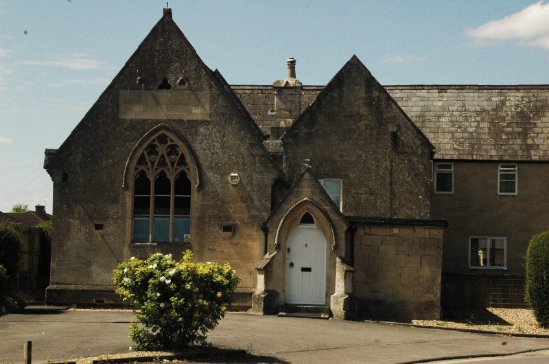
1594 WEST HARNHAM
No 2 (Old School)
SU 1329 10/535
II
2.
Circa 1850 former school and school house. T plan with former school hall
to east and house at right angles to west. Ashlar. East end of hall has coping
to gable end with finial. 3 light pointed window, stone mullions and tracery,
drip mould over on carved stops. Projecting gabled porch to right. Drip mould
over pointed arched door. South elevation of hall has coved cornice to eaves
decorated with ball flowers and 2 finely carved dogs. 2 3 light stone mullioned
cusped headed windows with flat drip moulds over. The adjoining gable end
of house 2 light stone mullioned 1st floor windows, drip mould on carved stops,
trefoil in gable and on ground floor canted head roofed stone bay windows.
West front has 2 light stone mullioned windows to both floors, gables over
on 1st floor, drip moulds ground floor. Central doorway with shaped head and
trefoil over, pointed drip mould on carved stops. Picturesque with grouped
chimneys.
Listing NGR: SU1352829129
External links are from the relevant listing authority and, where applicable, Wikidata. Wikidata IDs may be related buildings as well as this specific building. If you want to add or update a link, you will need to do so by editing the Wikidata entry.


Other nearby listed buildings
