Latitude: 53.689 / 53°41'20"N
Longitude: -1.5057 / 1°30'20"W
OS Eastings: 432740
OS Northings: 421509
OS Grid: SE327215
Mapcode National: GBR KTXS.TB
Mapcode Global: WHC9Z.VJ5S
Plus Code: 9C5WMFQV+JP
Entry Name: 15A, Wentworth Street
Listing Date: 1 February 1979
Grade: II
Source: Historic England
Source ID: 1258723
English Heritage Legacy ID: 445560
ID on this website: 101258723
Location: St Johns, Wakefield, West Yorkshire, WF1
County: Wakefield
Electoral Ward/Division: Wakefield North
Parish: Non Civil Parish
Built-Up Area: Wakefield
Traditional County: Yorkshire
Lieutenancy Area (Ceremonial County): West Yorkshire
Church of England Parish: Wakefield St John the Baptist
Church of England Diocese: Leeds
Tagged with: Building
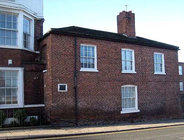
1. WENTWORTH STREET
5115 (West Side)
No 15A
SE 3221 3/250
II
GV
2.
2 storey, 3-window red brick house of early-mid C19. Hipped roof of stone
slates. Stone cills and cantered arches to sash windows with glazing bars.
Included partly because integral with No 15 which is part of the St John's
square group.
Listing NGR: SE3274021509
External links are from the relevant listing authority and, where applicable, Wikidata. Wikidata IDs may be related buildings as well as this specific building. If you want to add or update a link, you will need to do so by editing the Wikidata entry.


Other nearby listed buildings